The Best Hike in Yoho National Park
My Story of Why You Should Hike the Iceline Trail

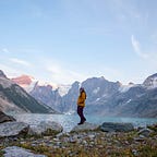
The Iceline Trail in Yoho National Park is hands down the most incredible trail that I have had the pleasure (and a little bit of pain) of hiking so far in my life. This is also the longest day hike that I have done, as we connected the Iceline trail to the Whaleback trail, then to Twin Falls and out. These trails together are meant to be backpacked over two or three days, however this is a story of doing them in the same day. We went in early July and the weather was pretty unpredictable all day. Although I loved the weather that we got — wasn’t too hot or too cold — if you prefer fairer weather hiking I would recommend waiting a little later in the summer or making sure you check the weather forecast before you head out. That being said, it was a long, but rewarding day. If you like waterfalls, glaciers and a lot of elevation, then this hike is for you!

A work friend and I set out at 5:30am, and drove the three hour distance from Calgary to the Takakkaw Falls parking lot. We started by heading up the trail to Takakkaw Falls, which standing at 1254-feet, is the second highest waterfall in Canada. After stopping and taking too many pictures (just kidding, there’s never enough) we started up towards the Whiskey Jack Hostel. This is where the trail starts.

The Iceline trail leads up to an absolutely stunning glacier field, so it makes sense that there will be a fair amount of elevation gain. Other trail on other hikes lead up nicely to any steep inclines, this one does not. It throws you right in from the get go. The trail up is well maintained and goes through beautiful forest and you keep a view of Takakkaw falls for the majority of this part of the hike. By the end of the first set of switchbacks you will be higher than the falls.

After this stint of the hike you will find yourself above treeline and for the next 10 or so kilometers the trail turns to rocks and moraines. It is a really interesting shift in the environment, and anyone who likes rocks will be especially excited to get to this point.


After this stretch of rocky road, there was a collective moment of awe as we had the pleasure of hiking over a hill that opened to an incredible view of the Emerald Glacier. There were a couple of other hikers in front of us and it was one of the coolest experiences I’ve had while hiking to hear the audible gasp when they crossed into view of the Glacier, then to have that same reaction a few minutes after when we arrived.


We decided to explore the glacier field for a little while and found a pretty small, but cool snow cave, then continued on as the weather started changing. Throughout the day we had beautiful sun, some snow, and a full on rain storm.

The next place that hikers will end up is called Celeste Lake. The access to this lake was closed because of trail conditions while we were there. There was a sign saying that continuing through would add an additional 3 km to the trip. I believe that this is where most day hikers will turn around or take the trail around Celeste Lake and head back down to the parking lot. We were already in it for the long haul, so we continued through and passed through even more amazing landscape.

There was an amount of relief that I felt when we came down from the glacier, because we had done a lot of up and not yet a lot of down. Just past the big clump of trees that you see above the trail heads downhill towards a large clearing and the Stanley Mitchell Hut. This area is really interesting to walk through. The most interesting thing that I found was the Warden’s Cabin which I had never seen in a park up until this point. I did spend a week in a decommissioned Warden’s Cabin in Skookumchuck, British Columbia just prior to this trip, and that made me even more interested in this cabin! (I’ll write about that too, eventually.)

From here you’ll see the hut and make your way over. There is a toilet here, so it is an excellent place to utilize before you continue on. The valley that you come to is also an excellent place to stop and snack and just take in the view. While we were hiking I had to stop every few hundred meters to take pictures of something different in the environment, be it a change of scenery, some plants or the buildings. Lucky for me that Tony was also the same. Patience in hiking and the outdoors is something that many people overlook.

After a short stop here, I found myself thinking that we must be almost done and almost back to the car. Boy was I wrong. I would consider this just over halfway from the start. Again to mention that this hike is meant to be completed over three days, and not in one. So we continued.

We followed along this trail until Tony asked me if I wanted to see some more waterfalls. Of course I said yes. Who doesn’t want to see more waterfalls? This is where we started Whaleback. If you wanted to do this hike in one reasonably long day, you could continue through and not go up Whaleback, but the view from the top in addition to getting to feel the power of Twin Falls and see an incredible snow pack, makes it worth the extra elevation. Tony said that it was only short way to the top of the next mountain and then to the waterfalls. So as we started climbing he pointed out where we had started from and that by the time we got to the top of Whaleback we would have done nearly the same amount of elevation as we had initially during the first portion of the hike. In retrospect, this was an incredible day and I’m sure the benefits to my body in going up more in elevation than I ever have was great, but at the time I was a little bit mad about having to go up again.

So I said that the views were great, but I forgot that we also went out in the peak of forest fire season and when the smoke would lessen the views were great. The smoke definitely added some difficulty to the hike as well.

Once we finished this part of the hike it was almost unbelievable to think that there was still more. The trail curves through windswept terrain with hundreds upon hundreds of small flowers and brush covering the ground. It also goes through avalanche terrain. There were parts of trail of that were entirely covered by snow and it was thanks to the footprints from the hikers who came before us that we had a clear trail through.

The trail turned into a rather wintery scene for the middle of summer. The next big thing is a bridge, which upon first glance looks pretty sketchy. There have been a couple of people who have died here, so I encourage anyone who decides to come up to Twin Falls to do so with a bit of caution and awareness of the surroundings. I should also mention that you can do Twin Falls or Twin Falls and Whaleback together as a decently long day hike without doing the rest of the Iceline Trail.

From here there is a path that goes down to the right and you can get very up close and personal with the waterfall. For us there was a rainstorm that very suddenly picked up, making the rocks slippery and conditions less than favourable. This is where that awareness comes in. The lesson of learning when to step down from an objective and where your personal limits meet the environmental limits is very hard to learn.

Something that came out of this picture was the idea that the right amount of adrenaline is something to be sought after. The power of the water brings out a feeling of excitement mixed with fear. When the rain came we booked it down the mountain on a trail that you have to seek out at the top to follow down. By this point I was wet and tired and we had walked so far. I thought that we had to be close to done. Close to the bottom. Close to the car. Right? Nope. We still had another 10ish km to go.

At the bottom of Twin Falls there was a tea house that appeared to be closed and had a sign answering all of the silly questions that people would come in and ask. This made the wet and the tired a little better.

From here out the trail was reasonably flat (other than one large rocky section) and didn’t take too much more physical effort to get out, just a lot of time. We decided to take the way of Marpole Lake back out, though I think there are two ways that you could take. Marpole Lake also showed evidence of a winter or spring avalanche. The path was entirely covered by trees, uprooted and entirely sideways.

After finding our way through the avalanche debris we continued on, and once again I thought, maybe we would be back at the car soon. Again, I was wrong.

From here there was one large rock pile where the path was hidden and you had to hope you would find the right rock and stay on the path.

From this point you pass the Laughing Falls and the Laughing Falls Campground, then cross more bridges and walk through the forest for what seems like forever and eventually after all of that, and watching the sunset, then continuing walking even further and realizing that we had been hiking for 10 hours, then 11 hours, then 12 hours. We finally arrived back at the parking lot and clocked our final time at 12.5 hours, over 1000 meters of elevation gain, 3 seasons of weather, 5 major water waterfalls, 1 glacier, 1 excellent work out, and one awesome experience.

Was it worth it? Absolutely. Was I little mad at Tony for taking me on this wild trip? Yes. Are we still friends? Also yes. Are we already planning to do it again? Absolutely!