Andrew ByrdinConveyalShaping the Transit Landscape of the Netherlands with Conveyal AnalysisEvaluating the impact of long-term public transport development plans for Amsterdam, Rotterdam, and The HagueJan 17, 2017Jan 17, 2017
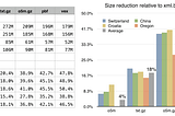
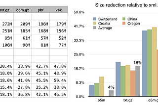
Andrew ByrdinConveyalSimpler OpenStreetMap Data Exchange, Part IILast spring I posted an article discussing some shortcomings of the PBF format and proposing a much simpler OSM interchange format…Feb 6, 2016Feb 6, 2016
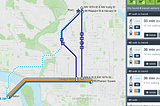
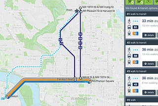
Andrew ByrdinConveyalVisualizing urban accessibility with OpenTripPlanner AnalystJul 2, 20121Jul 2, 20121