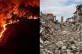
Vasundharaa Geo TechnologiesinDisaster AnalysisColliding EmergenciesThough COVID has become one of the largest challenges humanity has faced, it is not the only problem we will be facing in the times to…Apr 11, 2020Apr 11, 2020
Vasundharaa Geo TechnologiesURBANET 1.0Computer Vision Hackathon by Vasundharaa Geo TechnologiesApr 1, 2020Apr 1, 2020
Vasundharaa Geo TechnologiesinDisaster AnalysisTutorial 2: Burnt Area Extraction using Sentinel-2 data on UP42 PlatformThe year 2019 witnessed a record number of fire events. The California fires in the US, the Bandipur fire in India, the Amazon fires and…Feb 7, 2020Feb 7, 2020
Vasundharaa Geo TechnologiesinDisaster AnalysisTutorial 1: Flood Submergence Mapping using SAR imagery on UP42 PlatformSynthetic Aperture Radar (SAR) is an active radar sensing system that can produce high resolution radar images of the surface of the Earth…Jan 30, 2020Jan 30, 2020
Vasundharaa Geo TechnologiesinDisaster AnalysisAutomated Fire Assessment — The next level of forest fire monitoring.Forest fires, be it anthropogenic (human activity) or natural, degrades the ecosystem, human and animal life and infrastructure. 2019 has…Dec 17, 2019Dec 17, 2019
Vasundharaa Geo TechnologiesinDisaster AnalysisDisaster Impact Assessment Using GIS and Remote SensingDisaster management is all about knowing the right data, at the right time and initiating correct preventive and handling measures in…Oct 12, 2019Oct 12, 2019
Vasundharaa Geo TechnologiesinDisaster AnalysisMonsoon Misery — Assam FloodsIt has been nearly two weeks now since the rains have taken control over daily life of the northeast. Like night follows day, floods here…Jul 23, 2019Jul 23, 2019
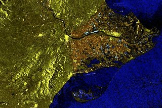
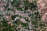
Vasundharaa Geo TechnologiesinDisaster AnalysisPALU LANDSLIDE - GIS based Disaster AnalysisGIS based case study of Palu landslide by Vasundharaa Geo Technologies.Jul 9, 2019Jul 9, 2019