Origin of surfable waves
Probably useful for surfers looking to extend their understanding of ocean waves beyond the star rating in your favorite forecasting app.
Stay for some explanation about waves, swell, period, wavelength, dispersion, surf forecasting. Part 2 for surfing statistics in Japan, attached dashboard & nerdy things about using python, Dash, docker, pandas, AWS for serving dashboards.
After starting to write about my dashboarding of surfing conditions in Japan, I noticed that I got too deep into the formation of surfable waves and surf forecasting so splitting the post in half. Anyway recently some people asked me how to read surf forecasts so maybe this post can help to understand what is needed for surfable waves. If you already know that stuff, I still recommend checking the videos I linked here. In the part 2 more about the dashboard project & surfing conditions in Japan.
Formation of swell
To be able to surf, waves needs to have a certain size and steep enough face so that a surfer can glide on it. Furthermore, the size is not everything. If the wave period is small and the sea is a mixture of different wave patterns, the conditions still suck.

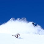
The birth place of surfable waves are the strong winds like in the photo above. Initially friction between the wind and the sea creates ripples, which will be pushed by the wind to even bigger ripples, eventually growing into big messy waves. For those interested in this part of the process, check the video here.

At some point the storm ends, moves away or waves propagate outside of the storm area. While the actual dynamics of ocean waves are complicated, roughly at open deep sea the wave speed is proportional to the square root of the wave length and at shallow waters to the square root of the depth. That means that at the open sea, the large wavelength (long period) waves travel faster than the short period ones. After a while the long period waves are separated from the small messy wavefronts, creating the “swell”. To sound smart, call it “dispersion” of waves (different wavelengths of waves traveling at different speeds). To know more, check this video (tells you also more about sets for example).

So after the waves have travelled and cleaned up to a proper swell they at some point approach the shore, hopefully at your favorite surf spot. There’s a bunch of factors determining how the wave itself breaks and depending on surfers skills or preferences different types of waves are in demand. Roughly the wave breaks when the wave height is 70% of the bottom depth. More about the shoreline dynamics here.
In surf forecasts as well as wave records data the swell period, height and direction are normally reported. Why talk about the wave period instead of the wavelength? Because, once the waves approach shallow waters, the speed of the wave and the wave length decreases, but the period stays constant. A decent surfable swell starts from 9s period. Well depends on opinion, might be still quite crappy on Indo standards but great somewhere else. Swell height from maybe 0.7m starts to be “surfable”, but again matter of opinion, spot and size of your surfboard.
Wind direction
For good surf conditions, one need decent swell, but that is not enough. Wind from the sea, onshore wind, creates small waves which mix up with the already cleaned swell. This makes the sea bumby and “mushy”. In addition the wind presses the waves to break earlier making the waves less steep.
The offshore wind has less effect on the waves, possibly making them even more steeper compared to no wind case. Since we surf close to the beach, the wind from the land doesn’t have time to make any significant waves to mix up with the beautiful base swell.
As a summary, we want offshore wind direction or all most no wind for good conditions.


So to summarize, for good surfing conditions to formulate, one needs a storm or at least strong winds far away to generate the ripples, which will then pack into bigger waves. These waves need some time, typically at least a day, to travel at the open sea. During this time the long period waves travel faster and separate from the low period mess. After this separation of periods, the long period waves are cleanly separated to “a swell”, which should hit the beach in a suitable angle. Lastly, when the swell hits the beach, the wind should be blowing from the beach to the sea (“offshore wind”).
Diffraction and refraction
As mentioned before, in shallow waters the wave speed is proportional to the square root of the depth. Thus the shallower it comes, the slower the wave moves. This leads into waves wrapping a round obstacles like the peninsula or island below, phenomena called diffraction. Refraction is when waves push through for example a space between two islands.
This wave bending phenomena creates surf into places which are not in clear line of sigh to the original storm centers as well as affect the surf spot dynamics often like in the photo below.

Example of a surf forecast
We need decent swell height and period in a suitable angle, and no wind or offshore wind. Let’s take a snapshot of todays forecasts around Chiba, in Japan provided by windy.

The surf forecasting is a bit of an art form and normally requires knowledge of the local spots + sometimes the forecasts are completely off, but hopefully you got something out of this post. Next part is more focused on introducing a dashboard to visualize surfable waves in Japan.