Geolocating a Gang Leader Wanted by the FBI: An OSINT Explainer
This report shows how OSINT techniques were used to find the ‘home’ of a gang leader on FBI’s Te Most Wanted Fugitives list with a bounty of up to $2 million dollars.
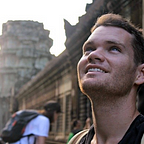
In April, CNN journalists interviewed Haitian gang lord Vitel’homme Innocent at his ‘home.’ It was located here: 18.5278, -72.2314.


Innocent, a notorious figure on the FBI’s Most Wanted list with a bounty of up to $2 million, is the leader of the Kraze Barye gang, infamous for his violent activities and kidnappings. He is also on the sanctions list of the UN and EU.


It should be noted that in the CNN interview, he is asked if it is his home, to which he appeared to confirm. It is not known whether this really ishis home, or if it is still his home, given that it was broadcast on CNN.
Understanding the exact location of a dangerous gang leader is crucial, even if he might have moved since the CNN interview. Innocent’s actions have severe implications, making details of his location of significant interest.

Using Open Source Intelligence (OSINT) techniques, I was able to trace the location of his residence based on the CNN footage. Here’s how I did it.
I examined the CNN footage linked below, looking for any geographical clues that might be present on satellite imagery.
At 01:04 in the video, several key features were visible: a large wall, a factory roof, a road turn, and a mountain range surrounding Port-au-Prince, Haiti’s capital.
By using the 3D elevation feature seen in Google Earth Pro (free to use), I was able to verify the mountain range feature, which helped confirm the location. If you want to learn how to do this, I have a YouTube tutorial on how to use Google Earth here.
These details led me to the coordinates 18.5447, -72.2359.


Further clues came from distinctive architectural elements. For instance, a unique street wall in the footage was easily identifiable and helped narrow down the location.


Nowe I had an understanding of the direction they were headed, and the rough area, I started to look for the specific property where the interview happened.
From studying the video closely, it’s fairly clear that the roof would have been orange, given the colour in the video, and a lot of mansions have orange roofs in this area .

I used Google Earth, looking at all of the orange-roofed buildings for the same design and shape as the one seen in the CNN footage.
The final area was just over 1.6km from the route videos, so it took a bit of scrolling to find.

By comparing the footage filmed at the ‘home’ the CNN team met Vitel’homme Innocent at, it was fairly clear it matched the building seen here: 18.5278, -72.2314.
The main giveaways were features such as the double triangle roof seen from the side, the entrance was at the end of the street, and construction next door.

One of the things that made this geolocation easier was a reference image I made of what the area would look like on a map, from what I could see in the footage.
The image below shows just how much can be gleaned from footage alone, in comparison to the satellite image. I made the reference image in Canva.


This geolocation effort took about four hours in total, with a few failed attempts at the start. However, it does show that with patience and meticulous research, anyone can perform such investigative work.
For those interested in learning these skills, I offer free OSINT tutorials on my YouTube channel.
Geolocation is a powerful tool in uncovering critical information and can be instrumental in various fields, from journalism to law enforcement.
These findings were first published on X (formerly known as Twitter) here.