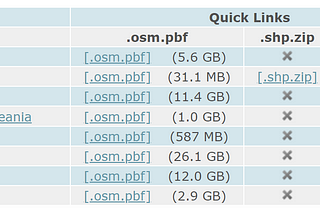
PinnedCase RobertsonGeocoding with OpenStreetMap: A Step-by-Step Guide to Convert Addresses into Geographic CoordinatesGeocoding is the process of converting a description of a location, such as a physical address, into a geographic coordinate, which is a…Apr 21, 2023Apr 21, 2023
PinnedCase RobertsonOSM and QGIS IntroQGIS is a free and open-source geographic information system (GIS) that allows you to view, analyze, and edit spatial data. You can use…Jan 11, 20231Jan 11, 20231
Case RobertsonGIS Workflows with MATLAB: Features, Integration, and Real-World Use CaseIntroductionJun 14, 2023Jun 14, 2023
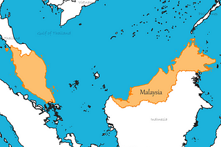
Case RobertsoninSoutheast AsiaExploring the Geography of Malaysia: Landscapes, Culture, and LandmarksMalaysia, a vibrant Southeast Asian country, is renowned for its stunning landscapes, diverse culture, and rich heritage. In this article…May 23, 2023May 23, 2023
Case RobertsonHow to Create a Thematic Map in ArcGIS: Step-by-Step GuideIntroductionMay 22, 20231May 22, 20231
Case RobertsonUsing Remote Sensing Techniques for Early Warning Systems: Applications and BenefitsRemote sensing techniques are a vital tool for monitoring and warning in early warning systems. With the ability to collect data from a…May 11, 2023May 11, 2023
Case RobertsonBuilding a Robust GIS Infrastructure Utilizing ESRI, SharePoint, AGOL, and Version ControlGIS Infrastructure Utilizing ESRI, SharePoint, AGOL, and Version ControlMay 1, 2023May 1, 2023
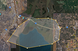
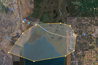
Case RobertsonWhy Do Measurements Differ Between Google Maps and Google Earth?When comparing measurements obtained from Google Maps and Google Earth, it is not uncommon to find differences in the results. These…Apr 26, 2023Apr 26, 2023
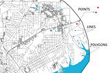
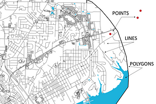
Case RobertsonGIS Essentials: Understanding Points, Polylines, and Polygons for Effective Geospatial…Geographic Information Systems (GIS) have revolutionized the way we perceive and analyze spatial data. At the core of GIS lie fundamental…Apr 26, 2023Apr 26, 2023