Dimitris SykasNavigating the EU AI System Database: A Comprehensive GuideThe European Union (EU) is pioneering regulations to ensure the safe and ethical use of artificial intelligence (AI). A key part of this…May 22May 22
Dimitris SykasWhat is an AI system?Let’s t try to understand what is and what is not an AI system under the EU AI ActMay 11May 11
Dimitris SykasUnderstanding the EU Artificial Intelligence ActThe main purpose of the EU Artificial Intelligence Act is to establish a harmonized set of rules for the developmentMay 10May 10
Dimitris Sykasincloudeo storiesSatellite imagery for agricultureThe evolution of satellite image data in the agricultural sectorMay 31, 2022May 31, 2022
Dimitris Sykasincloudeo storiesRemote sensing applications in agricultureHow geospatial technologies can assist throughout the farming lifecycleMay 19, 2022May 19, 2022
Dimitris SykasinGEO University Learning ContentUnderstanding agricultural risks with the GEO-Insurance platform — Use case in CataloniaThe GEO Insurance platform is an online platform for insurance companies and farmersMay 9, 2022May 9, 2022
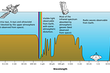
Dimitris SykasinGEO University Learning ContentA gentle introduction to hyperspectral remote sensingRemote Sensing has been identified as “the field of study associated with extracting information about an object without coming into…Dec 6, 2019Dec 6, 2019
Dimitris SykasinGEO University Learning ContentCredit Card Fraud Detection using Keras and RNow days almost everyone is using credit and debit cards to perform purchases from physical and online shops. Billions of Euros, USD, Yen…Sep 13, 2019Sep 13, 2019
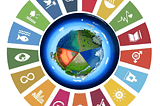
Dimitris SykasinGEO University Learning ContentEarth Observation and GIS to support the United Nations Sustainable Development GoalsThe Sustainable Development Goals are the blueprint to achieve a better and more sustainable future for all. They address the global…Oct 29, 2018Oct 29, 2018
Dimitris SykasinGEO University Learning ContentHow Earth Observation images are used to detect and map forest fires?Forest fires are one of the main causes of destruction of natural resources and this is observed on a global scale. Many countries…Oct 5, 2018Oct 5, 2018