PinnedFakhriy Ramadhan3D Terrain & RGB TerrainThe simplification of Earth’s surface topography is represented by contour maps, which have been crucial for various human activities such…Mar 7Mar 7
PinnedFakhriy RamadhanWeb-Apps: Public Transportation in Bandung CityI have lived in Bandung City for almost 20 years, and from what I experienced it is inevitable to avoid long traffic congestion during…Nov 24, 2023Nov 24, 2023
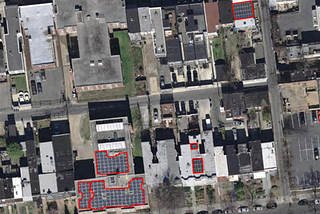
Fakhriy RamadhanRasterio: Image Segmentation Through Pixel ColorI collaborated with Imageryst in a compelling project about image segmentation. The input data is from scanned image that has not been…Mar 23Mar 23
Fakhriy RamadhanDigital Twins: 3D tiles building (Cesium, Maplibre, Xeokit)The concept of digital twins is to represent a digital version of a physical object, process, or environment, mimicking the behavior of the…Jan 31Jan 31
Fakhriy RamadhanThe current advancement of GIS and Remote sensing in energy fieldThis year’s GWF2023 event has enlightened me in many ways. With the booming use of AI in everyday life, it turns out that AI developments…Jun 17, 2023Jun 17, 2023
Fakhriy RamadhanSelecting Nearby Restaurants using Google Maps APIDeciding where to eat could lead to a problematic situation. Often find cases where the place is too far, too expensive, food is not…Mar 25, 2023Mar 25, 2023
Fakhriy RamadhanMultiple searches for planning travel destinations using Google Maps APIDeciding on a travel destination could be utterly complicated especially if you merely have a short time vacation. This happened to me…Feb 20, 2023Feb 20, 2023