Frank de MorsierinPicterraSatellite & aerial images at your fingertips!We have been pushing our platform to make you able to analyse your data in matters of minutes with the power of machine learning and our…Jan 10, 2020Jan 10, 2020
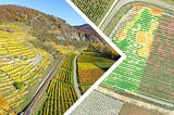
Frank de MorsierinPicterraVineyard monitoring right into your laptop!A couple of years ago remote sensing made its way into agriculture and it has since been powering a wide range of applications, supporting…Aug 28, 2018Aug 28, 2018
Frank de MorsierinPicterraMonitoring cadastral changes in near real-time: future or reality?It is way too often that the cadastral information (building footprints, roads, parcel boundaries, etc.) seen on online maps (Google, Bing…Jul 17, 2018Jul 17, 2018