23.4 degrees
The axial tilt of the Earth is 23.4 degrees, this is a really important attribute of our planet and plays a big role in making the Earth habitable. The tilt of the Earth causes seasons which sustain life. The angle of the Earth’s tilt oscillates between 22.1 and 24.5 degrees over a ~41,000 year cycle. Right now it is actually slowly decreasing which would normally cool our summers down and warm our winters up. That *isn’t* happening right now due to human caused emissions which are impacting our climate. This is not my opinion, it’s science. And if you are still skeptical or believe your uncles fake news posts on social media, read for yourself, here are the data: http://climate.nasa.gov/scientific-consensus/ http://climate.nasa.gov
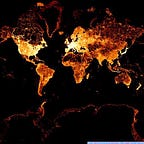
One of my favorite Earth Observing satellites is the Deep Earth Climate Observatory (DSCOVR) operated by NASA. It sits in the coolest location orbiting “L1” or Lagrange Point 1. A place between the Earth and the Sun where gravitational pull is null, about 1,500,000 km from Earth. From this vantage point, the Earth Polychromatic Imaging Camera (EPIC) takes images once every 2 hours with sensors measuring spectra in 10 different wavelengths. The other sensors on DSCOVR measure solar wind (and can warn us of large solar activities) and radiation. EPIC has a focal length of 2.8m which gives us a resolution of 25 km per pixel in the red, green and blue bands. Check out this image below from Sunday Dec 18th, close as I could get to the Winter solstice using NASA’s portal. Towards the top of the image (North), you can see the Mexico and the Southwestern United States. If you zoom in, California is very visible. As for Canada and Alaska, they are basically at the “top” of the planet where we would expect the north pole. This is why we have polar night in the winter and midnight sun in the summer: during the Winter solstice, the tilt of the Earth keeps the high northern latitudes in the darkness throughout the rotation of Earths 24hr period. Conversely during the Summer solstice, the tilt of the Earth keeps high northern latitudes in the light throughout the 24hr period.

Compare this to the same observation made during the 2016 Summer solstice. Now the Unites States is toward the “middle” of the image, much further South compared to the Winter Solstice. It’s hard to make out, but most of Canada and Alaska are now basking in the sun as well.

Here’s the thing: the Earth may have a 23.4 degree tilt, but the difference (delta) between the Winter and Summer solstice is effectively double: 46.8 degrees. Another way of saying it, today (winter solstice) in the northern hemisphere we are leaning “back” at 23.4degrees whereas at the summer solstice we will lean “forward at 23.4degrees:
Given that the “field of view” from the Sun to the Earth is 180 degrees (i.e. sunlit side of the Earth), the shift is essentially 1/4. (46.8 into 180). This is why Antarctica disappears when comparing Winter to Summer solstice. This is also why in a place like Colorado we have temperatures of -20 degrees C and during the summer it can reach +40 degrees C.
Himawari-8 is a Japanese weather satellite that orbits the Earth in a Geostationary orbit. At this orbit height, the orbital period is equal to Earth’s rotational orbit, making the satellite appear “fixed” from an observation made on Earth. (There are a lot of satellites in this orbit) Because of this orbital position, Himawari-8 sees sunrises and sunsets everyday. Here is the Summer solstice GIF:

And a Winter solstice GIF, notice the (46.8 degree) difference?

Orbital dynamics are an amazing phenomena. When you look to the skies, create a mental picture where you are on the Earth (latitude), and what part of Earth’s rotation (time of day) and place on the orbit (season) you are in. Mathematics allow us, with real precision, to model future orbits and positions. Here is an image from my backyard in Colorado from 40 degrees latitude, at high noon, on the Winter solstice. The sun is just at a 26degree angle from the horizon. “Low” in the sky but Alaskans and Canadians are no doubt jealous.