LaurayuanWhat is LiDAR Intensity and How is it Used?LiDAR, which stands for Light Detection and Ranging, is a remote sensing technology that measures distances by illuminating a target with…Aug 23Aug 23
LaurayuanAchieving High-Accuracy Drone Mapping: GCPs vs. RTK vs. PPKAccuracy is essential in drone mapping, photogrammetry, and aerial surveying. While the Global Navigation Satellite System (GNSS)…Jun 4Jun 4
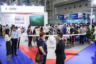
LaurayuanJOUAV Wows Crowds at Drone Expo 2024 with Cutting-Edge TechShenzhen, China — June 4, 2024 — JOUAV, a leading industrial drone company, took the 8th Drone World Congress and the 9th Shenzhen…May 27May 27
LaurayuanJOUAV to Showcase Groundbreaking VTOL UAVs and LiDAR Technology at InterGEO 2023[CHENGDU, CHINA, September 22, 2023] — JOUAV is excited to announce its participation in InterGEO 2023, the annual conference and trade…Sep 22, 2023Sep 22, 2023