Solo Sierra High Route: Week 1
The Plan
The plan for Week 1 was to make it from Kings Canyon to Bishop Pass trail by the following weekend. Matt would bring all my food and refills needed for my resupply and pick me up at the Bishop Pass trailhead to spend a couple nights in a motel in Bishop. My Garmin InReach made it easy to share my progress and text Matt any updates to my plan as I hiked along each day.
Day 1
Before I knew it, Matt and I were spending the night in a motel just outside the entrance to Kings Canyon National Park. We woke early to make sure I would arrive at the ranger station in time to pick up my permit before the 10am cutoff. At 9:40 AM, I hoisted my backpack on and started up the Copper Creek trail with Matt joining me for the first few switchbacks.

I climbed 6,000 vertical feet of switchbacks up through meadows until reaching a ridge, at which point I began my first section of cross-country travel to Grouse Lake. I stopped at the lake for a snack, then ascended granite slabs up and over Grouse Lake Pass to camp in the basin beyond.


Day 2
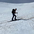
The next morning, I woke up a 30-year-old. I packed up and hiked up to Goat Crest Saddle, featuring a tiny blue tarn with a small snowfield.

I proceeded down a series of easy granite ramps and skirted around the edge of a serene meadow before joining up with the State Lakes Trail.


I hiked on trails for a few miles before jumping off again to hike steeply up Windy Ridge. This ridge marks the watershed boundary between the South and Middle Forks of the Kings River, known as the Monarch Divide.

I stopped to camp just below White Pass, exhausted from all the cross-country travel of the day and disheartened at how slow-going the off trail sections were proving to be.

Day 3
Day 3 began with sidehilling across a loose scree slope in a game trail, followed by the first few class 3 moves over some blocky granite up to White Pass. An easy traverse across slabs and snowfields led over to Red Pass.


From Red Pass, spectacular, sweeping basin of slate and metamorphic rock curved down a couple thousand feet to Marion Lake.

Marion Lake was my favorite lake of the whole High Route. Its crystal clear water over the white granite bedrock reflects the deepest blue of the sky. Its position nestled in a basin among unnamed peaks makes it difficult to reach; its shores are relatively untrammeled as a result.


I didn’t linger long at Marion Lake, knowing I had a difficult pass ahead. I ascended gently but slowly up to the lake below Frozen Lake Pass.


After circumnavigating the eastern shore of the lake, Frozen Lake Pass was reached via a 700ft ascent up a reasonably stable but steep talus slope.


From Frozen Lake Pass, the objective was to descend the steep scree slope to the lake, work down a talus slope to the flat basin, then contour left across the basin to meet up with the John Muir Trail before Mather Pass.

The ascent up to Mather Pass cruised by easily thanks to the astounding feat of engineering, dynamite, and manual labor known as the John Muir Trail.

On the way down from Mather Pass, I came across a PCT section hiker (nice chatting with you, Daniel!) who was looking for a nice spot to set up his hammock for the night. The campsite I was eyeing on the map was occupied, so we proceeded all the way to the outlet of the lower Palisade Lake before I decided to depart the trail and find a site amongst the granite slabs above the lake.

I set up my tent in the last of the failing light and heated up my dinner by headlamp. At the start of the day, I wasn’t sure if I would be able to make it over Mather Pass, so my excellent progress was a pleasant surprise and I ended the day in high spirits.
Day 4
My goal for this day was to make it to Dusy Basin, a full day of off-trail travel including climbing over three passes. Though the general direction was obvious, the detailed routefinding was a little tricky in spots climbing up out of the Palisade Lakes basin toward Cirque Pass. Class 3 scrambles up steep granite slabs flattened out on successively higher plateaus which often featured little tarns. Looking back from one of the higher plateaus, the lower Palisade Lake reappeared in the distance.

From Cirque Pass, I picked my way down to the unnamed lake in the basin below, crossed the outlet stream, and ascended the unforgiving terrain to Potluck Pass.

I climbed too high before cutting right to traverse across the granite slabs below Potluck Pass, which forced me into some arguably-class-4 (but fun!) moves. I also bonked pretty hard halfway up this pass; a sitting break and a granola bar helped raise my spirits to finish the ascent.
Potluck Pass, a relief of broad slabs cut into the ridge descending from Thunderbolt Peak, is nestled between dramatic spires of granite and dark rock.


A blessedly easy descent down gentle, predictable granite ramps led me to the largest Barrett Lake, a serene, remote lake replete with grassy banks, pikas, marmots, and mosquitos.

A long, flat cross-country hike led to the base of Knapsack Pass, an easy ascent if you find the right route. Fortunately, after one small class 4 move — resulting from my stubbornness and unwillingness to lose any altitude to find an easier route around the obstacle — I found a series of grassy ramps affording easy walking diagonally up to the pass.

About 100ft below Knapsack Pass, I looked up to see a person standing atop the pass with a glowing green halo surrounding his head — my very first encounter with another Sierra High Route hiker. The glowing green halo turned out to be a bandanna protecting his neck from the sun. We chatted briefly about how we had both taken the same wrong turn on the way up to Potluck Pass, how many days we had been on the route so far, and our resupply plans, then I let him get ahead of me while I took some photos from atop the pass.

I picked my way down the slabs and boulders until I encountered some sparse stands of pine trees, then traversed the rolling terrain all the way to the Bishop Pass Trail.


I briefly joined up with the trail until I found a use trail leading off toward a nearby stream, where I happened across an excellent campsite a sufficient distance from both the stream and the trail.

Day 5
To be continued…