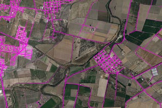
Michal MigurskiMapping Remote Roads with OpenStreetMap, RapiD, and QGISThis tutorial was originally part of a joint workshop between DirectRelief, NetHope, and Facebook at the 2019 NetHope Global Summit in San…Oct 31, 2019Oct 31, 2019
Michal MigurskiinPlanScoreScoring North CarolinaNorth Carolina got new State House and State Senate district maps this week. At PlanScore, we helped a number of observers and experts…Sep 23, 2019Sep 23, 2019
Michal MigurskiinPlanScoreOpen Precinct Data: Schema 0.1 ProposalHere’s a preliminary exploration of a new data format for storing U.S. electoral precincts, a follow-up to Open Precinct Data (April 2018).Dec 27, 2018Dec 27, 2018
Michal MigurskiinPlanScoreHow It’s Made: A PlanScore Predictive Model for Partisan ElectionsWith the mid-term elections in full swing and campaigns focused on the districts we have, PlanScore has had a quiet few months. Earlier in…Nov 3, 2018Nov 3, 2018
Michal MigurskiinRemixMicromobility Data Policies: A Survey of City NeedsIn the past year, cities have been prompted to rapidly re-examine the management and regulation of transportation services due to the…Oct 17, 20185Oct 17, 20185
Michal MigurskiinPlanScoreOpen Precinct DataSeveral weeks ago, I spent an extended weekend at the fifth (of five) Geometry in Redistricting conference. Apart from speaking and…Apr 9, 20183Apr 9, 20183
Michal MigurskiinPlanScoreScoring PennsylvaniaOn February 13 we launched PlanScore.org into the whirlwind of Pennsylvania’s disputed congressional plan. Our mission is to help citizens…Mar 1, 2018Mar 1, 2018
Michal MigurskiinRemixComing To A Street Near You: Help Remix Create a New Tool for Street DesignersWe’re launching a new product to design better streets for people, on top of a completely new data standard.Jan 17, 2018Jan 17, 2018