Toitū Te Whenua LINZinOn LocationUsing macrons for te reo Māori with GISLearn about the use and importance of macrons for te reo Māori with GIS, including UTF-8 character encoding, fonts and databases.May 24, 2021May 24, 2021
Toitū Te Whenua LINZinOn LocationWhich Coordinate System to use in New Zealand?It can be difficult to be sure what coordinate system to use. This post provides guidance on the best coordinate systems to use in NZ.Apr 21, 2021Apr 21, 2021
Toitū Te Whenua LINZinOn LocationIdentifying trees using RA few of our older elevation datasets often have point cloud classifications that simply differentiate ground and above ground. If we want…Oct 11, 2020Oct 11, 2020
Toitū Te Whenua LINZinOn LocationReprojecting point clouds to NZVD2016Reprojecting your LAS/LAZ point cloud files between NZ Local Vertical Datums, NZVD2016 and NZGD2000 using free and open source software.Dec 9, 2019Dec 9, 2019
Toitū Te Whenua LINZinOn LocationNew pilot datasets for river namesWe’re pleased to release two new pilot datasets — NZ River Name Lines and NZ River Name Polygons.Aug 8, 2019Aug 8, 2019
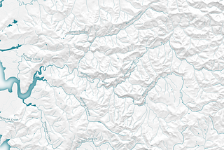
Toitū Te Whenua LINZinOn LocationFrom points to pixels — creating digital elevation models from OpenTopography point cloudsLearn how to create Digital Elevation Models (DEM) and Digital Surface Models (DSM) directly from point cloud data with OpenTopography.Jun 4, 20191Jun 4, 20191
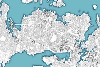
Toitū Te Whenua LINZinOn LocationAn open building outlines dataset for New ZealandToday, we’ve released NZ Building Outlines on the LINZ Data Service.May 10, 20191May 10, 20191
Toitū Te Whenua LINZinOn LocationCreating point cloud visualisations with OpenTopographyLand Information New Zealand has a partnership with OpenTopography allowing 3D point cloud data to be downloaded, processed and visualised…Oct 16, 2018Oct 16, 2018
Toitū Te Whenua LINZinOn LocationNZ Imagery Surveys dataset now availableWe’re excited to release NZ Imagery Surveys — a new dataset that provides a central source to find out about the aerial imagery that we…Sep 27, 2018Sep 27, 2018