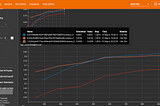
Open in app
Home
Notifications
Lists
Stories

Write
rexy.ai
rexy.ai

Home

May 9

Spatial resolution & object detection accuracy

At rexy.ai we work a lot on object detection on satellite and UAV images. Our platform is built to cover entire workflow of a typical “AI” project in geospatial: annotate GeoTiffs, train computer vision models and integrate AI model or model results with a business application. …

Satellite Imagery

4 min read

Spatial resolution & object detection accuracy

Apr 15

Satellite Images analytics for humans

TL;DR rexy.ai builds a platform which radically simplifies AI on satellite and drone images. It allows to train highly accurate object detection models with no-code and use them to geo-locate objects on full-size (100,000+ pixels) Cloud Optimized GeoTIFFs (COGs) in real-time. It’s even not necessary to upload files — rexy.ai …

Satellite Imagery

4 min read

Satellite Images analytics for humans
rexy.ai

rexy.ai

Help

Status

Writers

Blog

Careers

Privacy

Terms

About

Knowable