Roger FonginPicterraPushing the limits of Earth Observation Imagery with SARPicterra is a company that sits at the intersection of two rising domains. The first is the geospatial domain and more specifically Earth…Apr 15, 2021Apr 15, 2021
Roger FonginPicterraPushing the limits of Machine Learning with Capsule NetworksIn our previous post about pushing industry limits we talked about SAR data. We now switch attentions to the domain of machine learning…Jan 13, 2021Jan 13, 2021
Roger FonginPicterraGoing green with Aerial Imagery & PicterraThe combination of geospatial and machine learning is a certainly a hot topic these days for practitioners of both domains. There are…Jan 8, 2021Jan 8, 2021
Roger FonginPicterraSetting your detector’s resolutionThis week (22/09/20) we’ve released a new addition to your detector settings. The new setting is called ‘Spatial Resolution’ and it allows…Nov 12, 2020Nov 12, 2020
Roger FonginPicterraPicterra & Machine TeachingThe role of human guidance vs big data in Machine LearningMay 13, 20201May 13, 20201
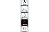
Roger FonginPicterraTesting Areas and the Training WorkflowA new tool to facilitate more generalizable and accurate detector building.Feb 10, 2020Feb 10, 2020
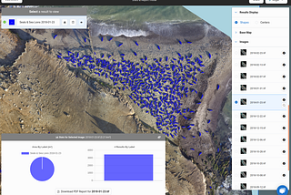
Roger FonginPicterraHow to prevent animal extinctions with drones and machine learningWildlife survey across multiple flights: An application of Picterra at scale.Jan 23, 20201Jan 23, 20201
Roger FonginPicterraOn the importance of proper data handling (part 2)Efficient Sampling with a QuadtreeDec 20, 2018Dec 20, 2018
Roger FonginPicterraOn the importance of proper data handling (part 1)Handling XView satellite imagery with YOLODec 18, 2018Dec 18, 2018
Roger FonginPicterraThe XView Dataset and Baseline ResultsHey there reader! Today we’re going to be talking about an exciting new object detection competition released by DIUx at the Pentagon (yup…May 25, 20181May 25, 20181