Trafford Data LabAlt text for dynamic plots in ShinyAdding informative alternative text (alt text) to images is a fundamental principle of web accessibility. Currently Shiny does not have an…Aug 13, 2020Aug 13, 2020
Trafford Data LabExploring tweets in RThis tutorial shows you how to use the rtweet R package to retrieve tweets from Twitter’s REST API and explore the results using tools…Jan 8, 20201Jan 8, 20201
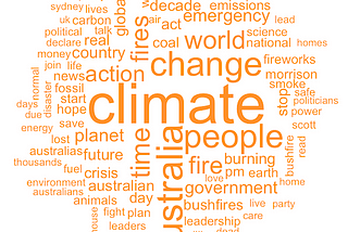
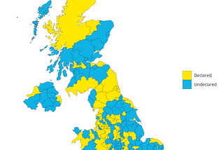
Trafford Data LabCleaning up data for a climate emergency[M]ankind is challenged, as it has never been challenged before, to prove its maturity and its mastery — not of nature, but of itself.Sep 25, 2019Sep 25, 2019
Trafford Data LabPushing the boundaries with the Open Geography Portal APIThe UK Office for National Statistics' Open Geography Portal provides a range of geospatial datasets under the Open Government Licence 3.0…Mar 27, 2019Mar 27, 2019
Trafford Data LabLet’s Make a Map in Vega-Lite*This is a short introduction to creating choropleth maps in Vega-Lite. We’ll show you how to load geospatial data, customise maps and join…Feb 11, 20191Feb 11, 20191
Trafford Data LabTake back control … of your data visualisationsMost local government employees reach for spreadsheets when they need to create a chart. However, spreadsheet programs can reinforce bad…Jan 16, 20191Jan 16, 20191
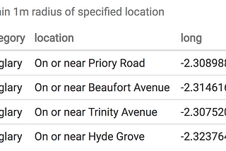
Trafford Data LabAnnouncing Crime ScannerOpening up government data enables third parties to develop innovative new tools that can help public services and the citizens that they…Nov 30, 2018Nov 30, 2018
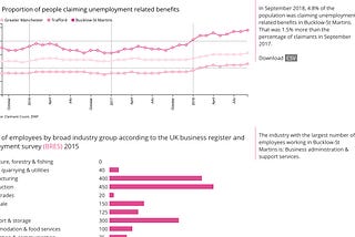
Trafford Data LabImproving the discoverability of worklessness dataThe Trafford Data Lab is involved in one of the six EU-funded OpenGovIntelligence (OGI) pilot projects which aim to make better use of…Nov 5, 2018Nov 5, 2018
Trafford Data LabOut of reach? Introducing our distance and travel time pluginThe Trafford Data Lab have just released their Reachability plugin for LeafletJS, an open-source JavaScript library for interactive maps…Sep 21, 2018Sep 21, 2018
Trafford Data LabQuerying APIs in RGovernments and other organisations often make open data available through Web service Application Programming Interfaces or APIs. The…Jul 26, 20182Jul 26, 20182