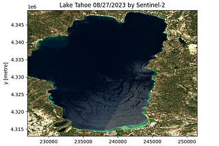
Mahyar Aboutalebi, Ph.D. 🎓inTowards Data ScienceA Simple Way for Downloading Hundreds of Clipped Satellite Images Without Retrieving the Entire…Learn how to download a clipped Sentinel-2 image for any Area of Interest (AOI), Lake Tahoe here, with just 12 lines of script.Apr 262Apr 262
Justin Morgan WilliamsinBetter ProgrammingGIS Project With Python and GeoPandasA GIS project implemented entirely with PythonJan 28, 20221Jan 28, 20221
Aleksei Rozanov6 python libraries to make beautiful mapsAt some point any Data Scientist faces the need to analyze or model geo spatial data, and it can’t be done without the crucial visual part…Feb 1011Feb 1011
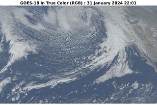
Mahyar Aboutalebi, Ph.D. 🎓inTowards Data ScienceWatching Storms from Space: A Python Script for Creating an Amazing ViewCreating an animation from geostationary satellite images to dynamically monitor storms in real-time using Python and Google ColabFeb 65Feb 65
Thiago CarvalhoinPython in Plain EnglishMapping with Python’s GeoPandasIn this article, I’ll discuss how to leverage the power of data visualization with maps, and I’ll explore the different ways of plotting…May 28, 2020May 28, 2020
Hazal GültekinConvert Address to Latitude Longitude using PythonIn this article, I am going to tell you “How to Convert Address to Latitutude Longitude using Geopy Python Library”. Full source code of…Aug 9, 20231Aug 9, 20231
Godwin MurithiinPython in Plain EnglishGeoPandas Tutorial — Part 1: Geospatial Data Handling and VisualizationSpatial data, encompassing Earth Observation, GPS, and mapping information, plays a significant role in our daily data landscape. Each data…Oct 21, 20236Oct 21, 20236
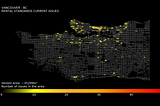
Milan JanosovinTowards Data ScienceIdentifying Topical Hot Spots in Urban AreasA generic framework using OpenStreetMap and DBSCAN Spatial Clustering to Capture the most hyped urban areasOct 16, 20233Oct 16, 20233