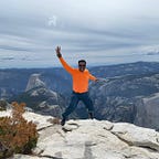
Spectacular Granite Dome Loop @Emigrant Wilderness
In recent years, at Yosemite National Park, finished Clouds Rest hike after dark and checked into hotel very late around 10:30 PM. All restaurants were closed on the way and around hotel areas by then. Ended up sleeping without dinner (after consuming emergency food supplies) and woke up early hungry and reached restaurant even before their open time. Restaurant owner noticed and took care early. While there were no other customers, ended up in long conversation with restaurant owner where we caught up on Yosemite tourist levels, summer season, fire season and how life changed in recent years. Got to my favorite question about “Where do locals go for escape, for fun away from tourists?”. Restaurant owner response was along lines of high way 108, Sonora Pass, Emigrant Wilderness and so on! After that, made few trips along suggestions received and got into habit of going back to Sonora Pass! In this trip, instead of running back to hotel every evening, looked into backpacking and stretch wilderness experience! Surprisingly, every day, amount of time spent in wilderness doubled in hours!

Emigrant Wilderness
1. Part of Stanislaus National Forest in the Sierra Nevada.
2. Known for spectacular alpine lakes, granite mountains, stunning Yosemite-like vistas without the crowds and relatively more solitude!
Nearest city Pinecrest, CA.
3. Permit: Required though Free at Summit Ranger Station!
4. Distance about 160 miles east of San Francisco and 50 miles south of Lake Tahoe.
5. Parked at Kennedy Meadows Trailhead lot
6. Borders: North side State Route 108 over Sonora Pass, South side Yosemite National Park, East Side Toiyabe National Forest and the Hoover Wilderness and West side Pinecrest city of California!
7. Surprises were amount of mosquitos and higher amount of water flow in creeks and streams even in late August (largely due to higher than normal snow levels in Sierras)!
8. Challenge Most of information available at Summit Ranger station is filed by hikers who chose to file reports. No real time data available. Most of guidance is general in nature. Expect surprises and Preparation for self sufficiency is best strategy!
9. Weather was perfect with cloud less clear blue skies! 80F in afternoon slowed down hiking pace with frequent stops though!
10. Mosquitos were atrocious and real big problem in trip overall. Based on information at summit ranger station, hard to avoid mosquitos. Despite covering head and body 100%, ended up with hundreds of mosquito bites during 25 hour hike over 3 days! Lot of blood from slapping mosquitos as well! Wanted to title this article as “Blood, Sweat, Tears @Emigrant Wilderness”!
11. Water stream crossings can be challenge right after rain/snow season. With no frequent/real updates available, seems better off hiking this loop later in summer versus early-summer. However this loop can be challenge within 1–2 weeks of rain in any season!
12. Quiet! Most hikers we run into is in first 3 miles from trailhead. After that, very quiet in overall 30 mile loop. Hard to expect any help. No mobile phone signal for throughout trip in wilderness area. Only signal received was for brief period near 10,000 ft level.
13. Fellow hikers: very helpful, offered most useful information, ran into 3–5 sets per day.
14. Snakes: With mid-day temperatures up to 80F, thought will run into snakes on trail. In last hour of hike, ran into dead snake near parking lot.


New Purchases Made specific for this trip!
- Paper map for area, from National Geographic Maps
- Collapsible Water bottles (BPA free). Lot of flowing streams to collect water and filter
- Mosquito Repellent Coils to use around tent
- Mosquito Head Mesh Nets
Even want a change from routine?, Take to mountains providing unlimited opportunities to experience the Nature!! USA has about 800 Wilderness areas which provide 110 million square miles of space to explore! Just like air is only thing still free in this world, Nature is mostly free & waiting for you, Nature engages anyone interested, Nature lets anyone in love forget the world!! What are you waiting for? Let’s Go & Have Fun in Nature!!