The Midwest Isn’t Gerrymandered Because “All The Democrats Live In Big Cities”.
Michigan, Ohio, Pennsylvania, and Wisconsin are four Midwestern states that Barack Obama won in 2012. Despite this, he lost most of the districts in all eight of their state legislative chambers, which were all GOP-controlled then and now.
Whenever anyone brings up that this might be because the Michigan, Ohio, Pennsylvania, and Wisconsin state legislative maps were drawn to keep the GOP in power — because the states were intentionally gerrymandered — the same replies come: “Ah, it’s really because of geographic clustering! All the Democrats in those states have packed themselves together in dark blue districts in the big cities.”
These theories are sometimes accompanied by hand-waving about how blue Philadelphia looks on a map and the troubles Ohio Democrats would have if Cleveland and Columbus were suddenly destroyed by two meteors and so on. They usually aren’t accompanied by a detailed explanation or proof or anything, because on their own they don’t make any sense. There are plenty of Democrats outside big cities, and if Democrats have a “bad distribution”, it isn’t just because they’re too packed together. Also, gerrymandering exists.
The Basic Arithmetic Problem.
The stereotypical “urban packing” explanation of Republican-leaning maps has a basic arithmetic problem:
- State legislative districts have to be more-or-less equally populated, and:
- These states had majorities of Obama voters — more Obama voters than Romney voters — so:
- If all the Democrats really were in dark blue urban districts, then there would have to be enough of those dark blue urban districts to cover a majority of each state.
In other words: You can’t pack a majority of voters into a minority of districts, whether they’re in cities or not. If Democrats in Michigan, Ohio, Pennsylvania, and Wisconsin really were as “clustered” and “self-packed” into Detroit, Cleveland, Philadelphia, and Milwaukee as some people seem to believe, then all of those state legislatures would or could have Democratic majorities anchored almost entirely in safe, compact urban core seats.
Obviously, they don’t. So what’s really going on?
Needed: A Better Visual Approach.
The hand-waved stereotype isn’t baseless. Democrats really are strong in cities these days. And if you look at a standard election map, it sometimes does have a few dots of dark blue in cities and red nearly everywhere else:

But for this topic, the standard election map is part of the problem. It’s very good at expressing whether a given place is mostly Democrats or mostly Republicans, but it’s very bad at expressing where the Democratic voters are.
In my last article, I wrote about how Democrats wouldn’t have won in 2012 without voters from groups they don’t win overall, and about how this fact has been obscured by charts and graphics that break a simple general principle:
If you want to visualize a group, then visualize the whole thing, with every subgroup sized proportional to the whole.
What might our graphics look like if we followed that principle? We’re trying to understand the split between Democratic and Republican voters, both inside and outside of big urban areas, as well as the same split between Democratic and Republican districts. Why don’t we break voters down into Obama and Romney supporters in urban and non-urban areas, and compare that to districts broken down the same way?
For example, here’s what the above approach gives for the Ohio State House. Is it surprising, given what the above map looks like?

Everyone says Democrats are badly allocated in Michigan because they’re all packed into Detroit. Here’s what the a similar chart gives for the Michigan State House:

Obama actually won plenty of voters outside of Greater Detroit, defined rather broadly, and Kent County (Grand Rapids): About a million of them, in fact. He lost “outstate” Michigan 48–52, not 0–100.
The problem Democrats have is that those voters aren’t in districts Obama won. He got 48% of the vote in outstate Michigan but won just 29% of its State House districts. As you can see, that disparity turns an Obama electorate into a Romney state house.
The same is true for Pennsylvania. If Pennsylvania is Philadelphia and Pittsburgh with Alabama in the middle, then Alabama sure gave Obama a lot of votes:

Again: Obama may have lost Pennsylvania outside of Philadelphia, its collar counties, and Allegheny, but he still won 44% of its vote. Unfortunately for Democrats, he won just 23% of its state house districts. You can make similar graphics for the other chambers in Ohio, Michigan, and Pennsylvania and for the Wisconsin legislature.
A Different Kind Of “Geography Problem”.
None of this should be surprising. Once again: You can’t pack a majority of voters into a minority of districts. What you can do is pack part of a majority of voters into a minority of districts, and dilute/crack the rest of them. Whether by “geography” or by intention, the Michigan, Ohio, Pennsylvania, and Wisconsin state legislative maps do just that. In particular, Democrats are underrepresented outside of big metro regions in these states.
Is that because of intentional gerrymandering? No, not necessarily — at least not entirely. No map consisting of single-member districts can be proportional at every scale (unless every district is 100% for one party or the other — for example, if every district consists of only one voter). Zoom in enough and they’ll pretty much necessarily under-represent the weaker party and over-represent the stronger party. Even in Illinois, Democrats are somewhat under-represented in the legislature outside of Cook County. Mitt Romney won 15% of the vote in Manhattan but 0 of its 12 of its Assembly Districts, and it’d probably be damn hard to draw two Romney districts in Manhattan.

But however much Democratic under-representation outside of big metro areas is the result of “geography”, not intentional gerrymandering, it’s the opposite of the “distribution problem” everyone keeps repeating. Those Democrats in exurbs, small cities, and rural counties are not too clustered. Like Republicans in Manhattan, they’re not clustered enough — they’re “self-cracked”, not “self-packed”. Even if it’d be difficult or impossible for a map to represent them proportionally, we may as well remember they exist.
Packed In Metros, Cracked Outstate?
All this just shifts the question: If it’s natural for Democrats to be under-represented, sometimes vastly under-represented, outside of big urban areas, then why aren’t they vastly over-represented inside of them? Gerrymandering is an advantage for one party over the other; the explanation has to include asymmetry.
Look at the Pennsylvania House again:
- Outside of the regions of Philadelphia, the collar counties, and Allegheny, Obama won 23% of the districts with 44% of the vote.
- Inside those regions, Romney won 30% of the districts with 37% of the vote.
In other words, the “urban” Republicans are underrepresented too, but less underrepresented than the “rural” Democrats. (This is shorthand, of course, since some of those “rural” Democrats are actually in cities like Erie, Scranton, or Harrisburg.)
So what about that? Is that the result of “geography” — of Democrats not just packed into urban counties, but packed within urban counties? Or is that the result of intentional gerrymandering? [1]
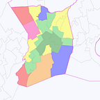
The Example Of Franklin County.
Personally, I think reasonable people can disagree on this point. There is some extent to which Democrats are undeniably “packed” within the urban regions of some states. If you’re from, say, metro New York City, then it might be a bit surprising how quickly the suburbs of, say, Columbus, Ohio turn pretty solidly GOP once you leave the city proper:

On the other hand, precincts aren’t people, and I also think it’d be naïve to deny the likely importance of intentional gerrymandering. Overlay the State House lines on that map. However “self-packed” Franklin County Democrats are, it sure seems like the lines have to do a lot of work, dividing the remaining blue here and drawing it in with dark red there, to get four mildly red districts.

Zoom in on other Democratic metros in Republican-controlled states — below is Cleveland/Akron/Canton in the Ohio State House, greater Philadelphia in the Pennsylvania House and Senate, and Detroit in the Michigan House — and you just might see a bunch of awkwardly-shaped districts that just happen to have voted relatively narrowly for Mitt Romney.

Yes, some of those weird boundaries follow city limits, and yes, these districts seem to often/mostly avoid splitting townships and counties. But…come on, they’re probably not maximizing the number of Democratic seats. Do studies about the behavior of randomly-drawn compact districts [2] seem that relevant when these are the actual maps? I will however concede that the Michigan House looks relatively compact.
And if maps like these are, somehow, “necessary” because of “geography”, again, it’s not just the Democratic “geography problem” that people talk about. All those light-red suburban districts have lots of individual Democratic voters. They’re just not clustered enough in any particular suburb, and/or they’re intentionally divided up.
Conclusion.
Two ideas have been flying around political discourse for a while: One is that a Presidential Democrat like Hillary Clinton just has to “reassemble the Obama coalition” of urban voters and minorities to beat a Presidential Republican like Donald Trump. The other is that Democrats have a bunch of unfavorable state legislative and Congressional maps precisely because all of their voters are in big cities.
Neither of these ideas really adds up, because both ignore how many voters Democrats have, and need, that aren’t in generally favorable demographics or regions. Obama wouldn’t have gotten to 50% with just the stereotypical “Obama coalition” groups, and he wouldn’t get to 50% in swing states without a lot of voters outside of large urban areas.
If you want to know what swing states would look like if the stereotypes were true — if Democrats had urban votes and nothing else — then look at some of their gerrymandered state legislatures. If you make the suburban, exurban, and rural Democrats electorally irrelevant, whether by intentional gerrymandering or by geography — instead of just forgetting they exist — then you get a bunch of Republican majorities.
There’s a curious potential silver lining for Democrats. They have a lot of voters in exurban and rural regions that help them win statewide but do them very little good at a state legislative level. There are also a lot of comparatively narrow Republican districts in closer suburbs.
If, hypothetically, Democrats were to pick up enough suburban Republicans, then they could lose quite a few of their exurban and rural voters and still end up better positioned to win statehouses than they are now — while being more, not less, “clustered” and “self-packed”. This is in fact the kind of shift that some polling suggests for the upcoming Presidential election, but I don’t know whether or not it will happen.
Notes:
- In Virginia, where most of the State House districts were won by Romney and most of the State Senate districts were won by Obama, the main difference seems to be that Obama won a few more State Senate seats (relative to the size of the chamber) in metro Richmond and Virginia Beach.
- Chen and Rodden made a kind of similar point to all this in their influential article on “Unintentional Gerrymandering”:
“By contrast, majority-Gore precincts outside of dense urban neighborhoods are often in the upper-left quadrant of the plots. In other words, rural, small town, and suburban precincts that lean Democratic are often subsumed into moderately Republican districts. As described above, there are isolated pockets of support for Democrats in African-American enclaves in the suburbs of big cities and in smaller towns with a history of railroad industrialization or universities. However, these Democratic pockets are generally surrounded by Republican majorities, thus wasting these Democratic votes. As a result, the Democrats are poorly situated to win districts outside of the urban core.”
Frankly, as innovative and interesting as the Chen-Rodden research is, I think it’s misleading to look at precincts rather than voters. Precincts aren’t real. People are real, and households are real, but precincts are small, somewhat arbitrary agglomerations of them drawn by governments. A sensible light red Republican precinct and a self-defeating dark blue Democratic precinct are both really just a bunch of dark red and dark blue dots of individual voters, since nearly every voter either 100% voted for Romney or 100% voted for Obama. (Yes, technically they’re really made up of households, or buildings, but either way.) Even when it’s impossible to draw proportional districts by combining precincts, it might not be if the precincts themselves were redrawn. That’s one reason I think it’s valuable to look at the distributions of voters, as I’ve done above.
3. My thanks to Stephen Wolf for the Franklin County shapefiles and the whole team at Daily Kos Elections for their incredible work calculating Presidential results by state legislative district — the foundation of this piece.