Guides ArenaTop 10 Best Laptop for GIS | 2024 | Best Budget OptionsGIS software is a subset of computer programs designed to let users generate and examine spatial data. Maps, spatial study, and data…1h ago
Robert SimmonWorking With Landsat Surface Reflectance Data in QGISSurface reflectance data is satellite imagery that has been processed to remove the effects of the atmosphere and the position of the sun…Apr 51
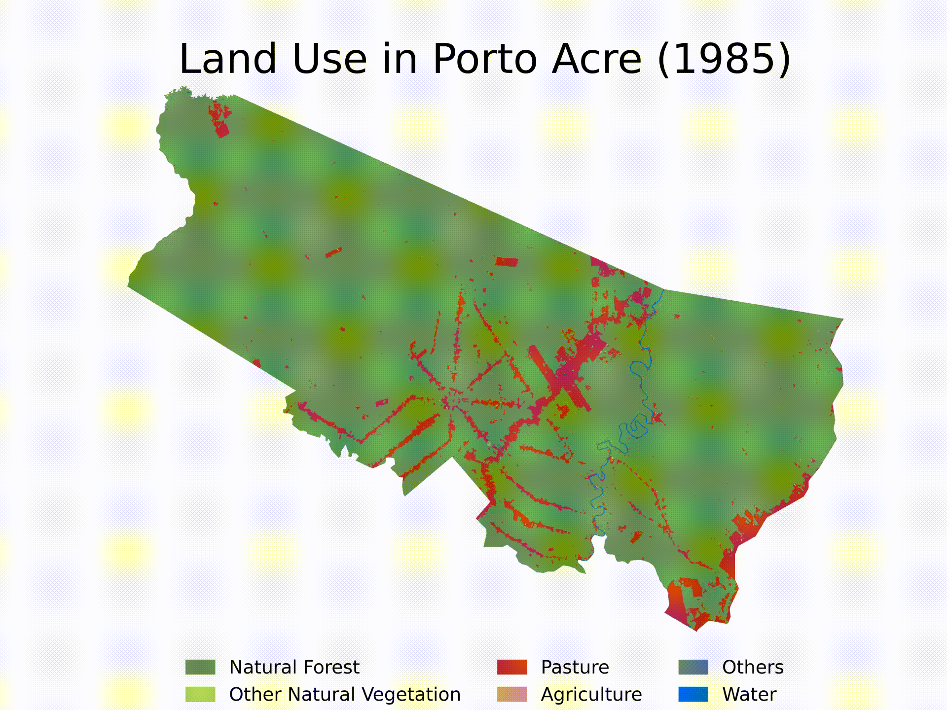
Vinícius HectorinTowards Data SciencePython + Google Earth EngineHow to clean MapBiomas LULC rasters for any shapefile in BrazilJul 101Jul 101
Bugingo DanielLost in Translation: My Adventure Across UTM Zones in UgandaWhen a seasoned GIS professional gets lost in their own maps, hilarity and enlightenment ensue.1d ago1d ago
René F. Najera, MPH, DrPHHot Spots and Cold Spots of Criminal Homicides in Philadelphia, 2023Using open data from Philadelphia and the US Census, we can quickly see where the “hot spots” and “cold spots” of homicide activity.Feb 223Feb 223
Guides ArenaTop 10 Best Laptop for GIS | 2024 | Best Budget OptionsGIS software is a subset of computer programs designed to let users generate and examine spatial data. Maps, spatial study, and data…1h ago
Robert SimmonWorking With Landsat Surface Reflectance Data in QGISSurface reflectance data is satellite imagery that has been processed to remove the effects of the atmosphere and the position of the sun…Apr 51
Vinícius HectorinTowards Data SciencePython + Google Earth EngineHow to clean MapBiomas LULC rasters for any shapefile in BrazilJul 101
Bugingo DanielLost in Translation: My Adventure Across UTM Zones in UgandaWhen a seasoned GIS professional gets lost in their own maps, hilarity and enlightenment ensue.1d ago
René F. Najera, MPH, DrPHHot Spots and Cold Spots of Criminal Homicides in Philadelphia, 2023Using open data from Philadelphia and the US Census, we can quickly see where the “hot spots” and “cold spots” of homicide activity.Feb 223
John Loewen, PhDinTowards AIBetter GPT-4 Prompting For Interactive Python Plotly GIS MapsMapping historical shipwreck data from Harvard data setJul 13
Emmanuel DavidsonVisualizing GIS Data with D3.js in a Quarto DocumentIn this guide, we’ll explore how to visualize GIS data using D3.js within a Quarto document. We’ll cover map projections, shapefiles, and…1d ago
John ListerGeospatial Function Calling with ChatGPTMost of the code in this example is based directly from this cookbook and has been adapted to work as a python terminal assistant executing…Feb 105