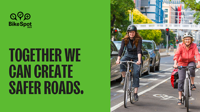
BikeSpot: Perceptions of Risk vs Real Risk
With increasing urban population and transport congestion it is important for a city to have bike riding as an attractive travel choice. The biggest barrier for people to choose riding a bicycle is the perceived lack of safety. How safe, or unsafe, people feel about riding a bike has a direct relationship with their willingness to ride.
With Melbourne still striving to become a ‘world-class cycling city’, we wanted to explore how our perceptions of riding risk compared with the real risk of riding at locations across Melbourne. For example, were there locations with a high-perception of risk and low real risk?
With CrowdSpot collaborators The Squeaky Wheel, we came up with BikeSpot and applied for a TAC Road Safety Community Grant.

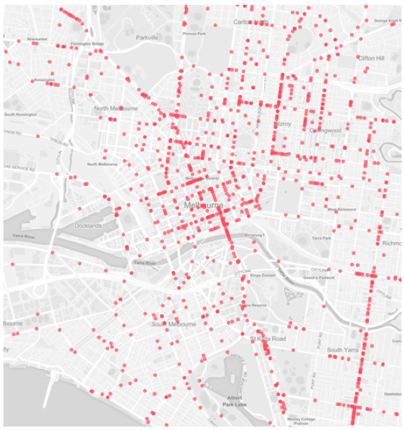
First, we needed to collect the perceptions of risk directly from the community. We started with a blank map (below) and launched with a forum at the Sustainable Living Festival on 14 Feb, 2016.
People had the option to add either ‘Safe Spots’ or ‘Unsafe Spots’ and also the ability to ‘Support’ (vote) and add comments on Spots added by other users. We also included the ability to switch the bike lane layer on or off.

In addition to our 13 Government Partners and 16 Community Group Supporters who promoted the project amongst their networks, articles published in The Age and ABC online gave the project a fantastic launching platform.
The map was open for public submissions for 2.5 months until 30 April 2016. We received submissions from over 2,000 people and had over 10,000 page views.


These strong participation results meant we were able to collect a huge amount of data on the map.

View the project map. (Note: can take a few seconds to load all the data).
Throughout Metropolitan Melbourne.

Over 8,000 submissions were made, comprising of 2,424 data points and thousands of comments and ‘Supports’.

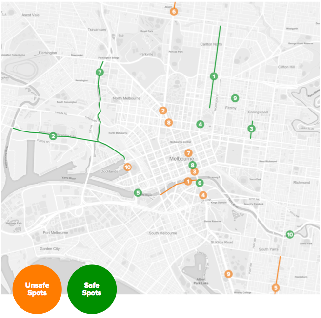
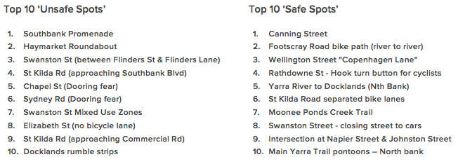
Top Unsafe and Safe Spots
By adding the number of comments and ‘supports’ a spot received we can determine the top 10 perceived ‘Unsafe’ and ‘Safe’ Spots across the entire city.
Perception of risk Vs real risk
A key aim of the BikeSpot project is to further understand differences in the perception of risk and real risk of riding a bicycle in Melbourne. We can do this by comparing each of the top 10 unsafe spots with historical crash statistics (VicRoads CrashStats).
It is important to note that VicRoads CrashStats data is generated through police crash reporting. As a result, these crashes tend to involve more serious injuries and therefore minor crashes often go unreported. CrashStats is still thought to be an accurate representation of bicycle crash locations, as was confirmed in the previous Cycle Stories project from 2013, where crowdsourced crashes were compared to CrashStats.
To define whether locations are deemed low, medium or high real risk we have applied the following categories based on the number of crashes that took place at that location under the same circumstances:
- Low real risk: < 5 crashes
- Medium real risk: 5–15 crashes
- High real risk: > 15 crashes
- Southbank Promenade
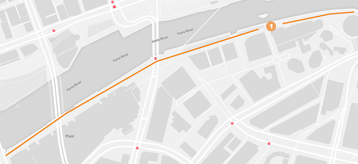
The strong mix of walking and cycling activity on Southbank Promenade elevated the busy corridor to being the most popular Unsafe Spot. The unpredictability of walkers or families with children creates a stressful riding experience. Despite this heightened sense of stress, official crashes to took place over the last 3 years. A factor in this result could be that bike riders travel at slower speeds and therefore only minor crashes occur, which are less likely to be captured by VicRoads CrashStats.
Crashes = 1
Low real risk
2. Haymarket Roundabout
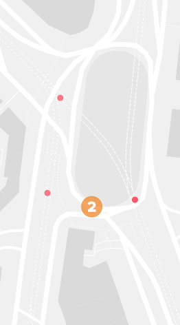
The Haymarket Roundabout, also commonly referred to as the ‘The Roundabout of Death’, is a well-known bicycle route landmark. The locations’ long-standing association with fear may have played a role in increasing its perception of risk. Despite improvements to the roundabout in recent years, there still appears to be confusion surrounding both cars and bicycles requiring the need to switch lanes.
Over the past three years, there have been a total of only 4 recorded bicycle crashes, thus posing only a low real risk. It is important to note that multiple unrecorded minor crashes could have taken during this time and that riders are extra cautious at this location due to their perceived high risk.
Crashes = 2
Low real risk
3. Swanston Street (between Flinders Street and Flinders Lane)
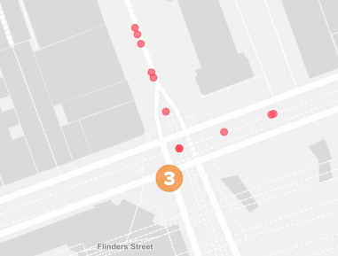
People perceive Swanston Street between Flinders Street and Flinders lane to be high risk riding environment. Riders describe being funneled into Swanston St and needing to squeeze between horse carriages and delivery vehicles on their left and moving trams (tram track) on their right. The cluster of 8 crashes within the past 3 years demonstrates that their a real risk factor at this location.
Crashes = 8
Medium real risk
4. St Kilda Rd (travelling north approaching Southbank Blvd)
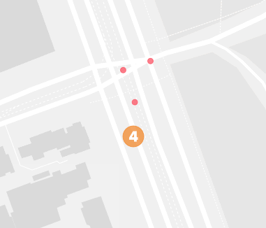
People riding north in the St Kilda Rd bike lane are required to merge right across two lanes of traffic in order to continue along St Kilda Rd. Despite being the 4th most popular Unsafe Spot there are only 2 crashes recorded at this location in the past 3 years.
Crashes = 2
Low real risk
5. Chapel Street (dooring fear)
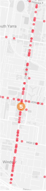
The risk of a car dooring crash on Chapel is very real. From a total of 89 crashes taking place on Chapel Street (between the Yarra River and Dandenong Rd) in the past 3 years, 40 were as a result of car doorings.
‘The closeness of cars, bikes, trams and pedestrians. As the cars are moving slowly, pedestrians frequently step out between parked cars, (as well as the well reported dooring problem). Also high frequency parking causes difficulties.’ - Mazza
Crashes = 89
High real risk
6. Sydney Road (dooring fear)
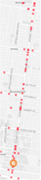
Similar to Chapel Street, Sydney Road is also a real risk for car dooring crashes. 73 crashes took place on Sydney Road between Brunswick Road and Bell Street in the past 3 years. 18 of those crashes are clustered at the southern end of Sydney Road, between Brunswick Rd and Glenlyon Road.
‘Lost count of the number of narrow misses by car-dooring and cars pulling out of side roads into the bike lane because they can’t see past the parked cars.’ - easyE
Crashes = 73
High real risk
7. Swanston Street Mixed Use Zones
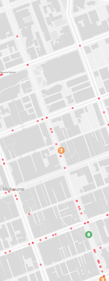
The shared walking and bike riding space at tram stops is a perceived safety concern amongst bike riders. The concern is related to both people stepping out on to the path to approach a tram and people walking on the path when they shouldn’t be. There are a number of crashes along Swanston St but none of them involve a pedestrian/bicyclist crash.
It should also be stated that there could be minor crashes at these tram stop locations, but these are less likely to be captured by CrashStats database.
Crashes = 0
Low real risk
8. Elizabeth Street (no bicycle lane)
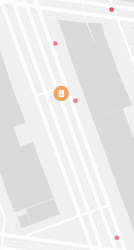
Elizabeth Street south of Queensberry Street is a perceived safety risk for bike riders as they must merge across lanes of traffic where there is no visible bike lane. There are 2 crashes at this location, both occurring as vehicles enter parking spaces.
‘The bike lane ends at Queensberry St. Riders need to merge across two lanes of turning traffic if they want to ride down Elizabeth St into the city. Cars beep and travel quite fast here. Every day I worry about this bit of my ride. We need a bike lane please.’ - Alex
Crashes = 2
Low real risk
9. St Kilda Road (approaching Commercial Road)
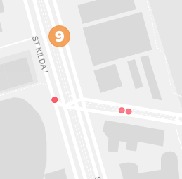
Travelling south on St Kilda Road the existing bike lane ends as the Commercial Rd intersection approaches. There doesn’t appear to be any crashes at this location within the past 3 years.
‘The bike lane here just disappears, (this happens all over the place, all the time. Too difficult? Just “dissapear” — problem solved — sheesh) and you find yourself stuck between cars straight on and cars turning left’.
Crashes = 0
Low real risk
10. Docklands rumble strips
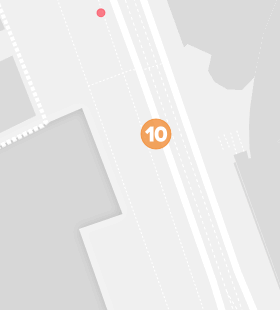
Whilst a popular route the Docklands bike path has a number of traffic calming measures including rumble strips. Bike riders attempt to avoid these sections and cross into walking paths and the road.
‘This is not safe at all — the ‘rumble strips’ force riders onto the bluestone paving either side of the main cycle track.’ -William Watt
Crashes = 0
Low real risk
In summary…

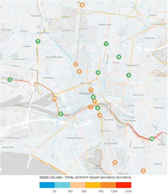
Do people actually ride at these locations?
There is a common thought that crashes might be lower at locations where there is a high-perceived risk due to people choosing not to ride at those locations.
The map below includes Strava volume data from a sample week in late 2015. The blue lines indicate low rider volume and orange/red lines indicate high rider volume, the majority of the top BikeSpot locations also correspond with high rider volume numbers.
Thus, while it appears that people continue to ride along bicycle corridors with high-perceived risk (likely due to convenience), a relatively low crash history may also be a result of extra caution being taken at these locations.
Conclusion
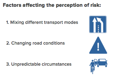
Seven out of the top 10 Unsafe Spots have ‘low real risk’ when compared to CrashStats data. Five of the low real risk locations are associated with mixing different transport modes. These locations present a high perception of risk but low real risk, possibly due to increased caution when riding and their relative predictability (you know which direction a car is travelling in a lane). This is in contrast to high real risk locations such as Chapel St and Sydney Rd, where dooring crashes are sudden and very unexpected.
Not surprisingly, the majority of Top 10 Safe Spots are all located along routes with strong mode separation.
The BikeSpot data comparison with CrashStats confirms, at least amongst the top 10 Unsafe Spots, that there is a great variation between the ‘perceived risk’ and ‘real risk’ at these locations. This means that even amongst confident existing riders, there are riding environments in Melbourne that are either uncomfortable or very stressful to ride in, despite them not having a reported high crash history.
While many of these high-perceived risk locations are not be captured by VicRoads CrashStats and therefore may not be a cause of serious injury, their existing conditions can prevent existing riders from riding more often and others from starting to ride. Crash statistics only tell part of the story. To become a world-class cycling city we need to also improve locations where people don’t feel safe.
For more analysis, take a look at the full BikeSpot report.
You can also explore the interactive BikeSpot bubble map visualisation.
BikeSpot Results in the media
The Age (11 July)
Channel 7 News (11 July)
ABC 774 Radio Interview (12 July)
Crikey (13 July)
The Herald Sun (21 July)