In-flight Weather Resources
#FlySafe GA Safety Enhancement Topic
The 21st Century has brought an unprecedented wealth of information to general aviation cockpits. Near real-time graphical and textual weather products contribute greatly to pilot situational awareness and decision-making. However, pilots must understand the capabilities and limitations of the equipment and the information it provides. Let’s explore how general aviation pilots can use available weather information sources to make well-informed weather decisions.

The Particulars of Preflight
Weather analysis and decision-making are crucial aspects of every pilot’s responsibilities. We are aware of the weather at our departure airport however en route weather is less predictable. Additionally, we need to know if weather conditions will permit a safe landing at our destination. Weather information gathering, analysis, and decision-making begin with the preflight and continue throughout. Throughout the flight, pilots should continually:
- Perceive present weather conditions and gather additional weather information from various sources.
- Process weather information by comparing present weather with forecasts and by relating present and expected weather conditions to aircraft and pilot performance capabilities.
- Perform by making operational decisions and acting upon them.
Our perception of the results of our performance decisions further informs and refines our analysis.
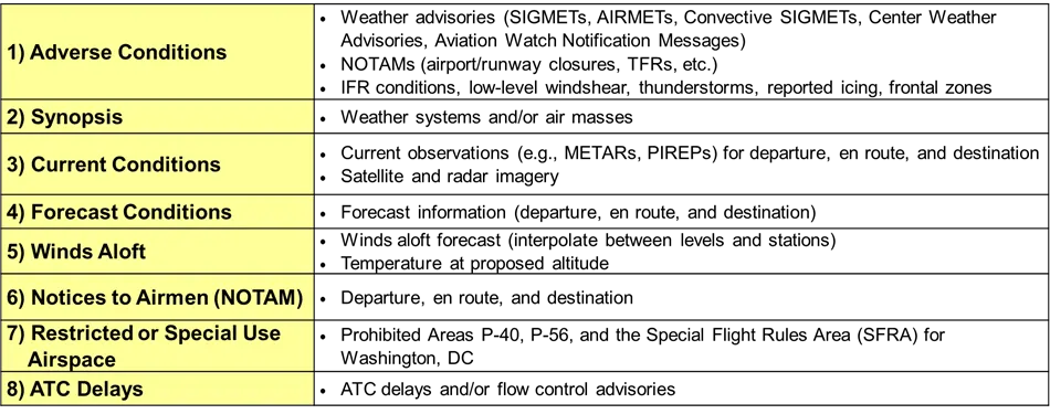
Regulations require that during pre-flight planning, pilots need to gather all pertinent information concerning each flight. In the past, this would require a pilot to call to a Flight Service Station (FSS) to acquire the needed data from a Briefer; however, today this information can be gathered using automated weather information resources. Pilots can still contact a FSS, but are highly encouraged to conduct a self-briefing before the call to ensure they have a good idea and understanding of weather conditions before speaking with a Briefer.
Pilots are encouraged to use the same list of elements for their preflight self-briefing that a FSS uses for a standard weather briefing. This list assists pilots in complying with 14 CFR section 91.103, regardless of the automated weather resource they use to gather the information.
Plenty of Sources
There are many weather information sources available today. However, it’s important to understand what each source offers and how to use that information to make an informed decision.

Whenever you access weather information it’s important to know how old that information is. Some of the data may be quite recent while others could be more than an hour old when you receive them. A lot can happen in an hour when it comes to the weather, that’s why it’s important to note the times when observations were taken and/or the product validity period.

Forecasts work best when you compare them with more current weather observations, that way you can see if weather is developing earlier or later than the forecast schedule.
A Real-time Picture is Worth a Thousand Forecasts
The FAA developed a weather camera program that started in Alaska to provide real-time visual and textual weather information to your computer or smartphone. Visit weathercams.faa.gov and click on any of the “dots” for real-time information.

These weather cameras were installed along air routes and areas with elevated accident rates to provide a source of data for preflight and inflight weather information. The implementation of the FAA’s weather camera service across Alaska resulted in an 85% reduction in weather-related accidents and a 69% reduction in weather-related flight interruptions from 2007–2014.
Today, the weather camera program maintains more than 230 camera systems in Alaska and Hawaii. They also host camera images from 280 non-FAA weather camera sites in Alaska, Colorado, Maine, Michigan, Mississippi, Montana, Utah, and across Canada. Camera angles include multiple views of actual conditions, a comparative “clear-day” image, and a 6-hour loop of previous images to show trends. The program plans to continue its expansion to the rest of the nation, improving aviation safety and efficiency in the general aviation environment and supporting the future of urban air mobility and advanced air mobility.
Monitor weathercams.faa.gov for added weather cameras and be sure to work them into your preflight planning and personal minimum checklists.
En Route Equipment
Although ADS-B In equipment is not required, there are some compelling reasons why pilots are considering installing it. En route ADS-B In service is available throughout the country and provides a suite of traffic, weather, and flight information products.
Universal Access Transceiver (UAT) equipped ADS-B In aircraft receive traffic information directly from UAT ADS-B out aircraft. ADS-R rebroadcasts traffic information derived from UAT and 1090 Extended Squitter positions so that even though the two systems don’t exchange information directly, traffic information is available to both. There’s also a way for ADS-B In users to see aircraft that are not ADS-B Out equipped. The ADS-B system transmits TIS-B data on both links to equipped aircraft flying within coverage. TIS-B uses data from ADS-B, radar, Wide Area Multilateration (WAM), and surface multilateration systems like ASDE-X to create accurate near-real-time position reports. In order to receive TIS-B information you must be ADS-B In equipped, within coverage of an ADS-B ground station and an FAA radar or multilateration system.
FIS-B information is available to UAT-equipped aircraft only. The system broadcasts aeronautical information products from the FAA and weather products from the National Weather Service.
Text and graphical FIS-B products available to ADS-B In users:
AIRMETs (AIRman’s METeorological Information)
- Convective SIGMETs
- SIGMETS
- METARS
- SPECIs
- National NEXRAD
- Regional NEXRAD
- D-NOTAMs
- PIREPS
- Special Use Airspace (SUA) Status
TAFs (Terminal Area Forecast)
- Amended TAFs
- Winds & Temperature Aloft
- Lightning
- Turbulence
- Icing
- Cloud Tops
- Graphical AIRMETs
- Center Weather Advisories
- TIS-B/ADS-R Service Status
Most of us are familiar with Automated Terminal Information Service (ATIS) available at most towered airports. ATIS provides basic weather and runway information, but what about non-towered airports?
Many smaller airports are served by ASOS or AWOS automated weather observing systems. In fact, most of the weather data used to produce aviation weather reports and forecasts is now gathered by automated systems. These systems are constantly updating weather observations and averaging the data to give an accurate picture of present conditions. There are about one thousand ASOS and even more AWOS systems deployed throughout the United States.

Most of the AWOS installations are a variation of AWOS-3 so you’ll have altimeter setting, wind, temperature (older installations may report in degrees Fahrenheit), dew point, density altitude, cloud and ceiling data. Newer installations may add precipitation type and thunderstorm/lightning information.

For those of us who can afford it, airborne weather radar is a very useful information source. It does require interpretation though and there are some limitations to consider. Airborne weather radar looks at precipitation and pilots know that the heavier the precipitation — the greater the associated turbulence will be. Because radar returns are immediate it’s a good choice for tactical weather avoidance. Heavy precipitation can mask additional precipitation behind it so it’s best to find wide clear areas so you can get a good picture of what’s beyond the radar return. If you’re a new radar user be sure to get some instruction on operation and interpretation before you base tactical decisions on radar information.
Another real-time solution is lightning detection equipment. Although it doesn’t show precipitation, it does indicate lightning strikes that accompany convective weather. Some installations integrate radar and storm scope information on a multi-function display. As with radar, instruction is highly recommended for new users.
Air traffic controllers are another in-flight weather information resource. They have the ability to show weather on their displays. You can also learn a lot by monitoring air traffic control frequencies. You’ll hear what pilots are requesting and what ATC can provide. If you make your weather decisions with that in mind, your requests are more likely to be granted. Once again — don’t wait until the last minute to request a diversion, ATC needs time to process your request.
Take Caution with the Climate
In-cockpit information displays can be compelling distractions so be sure not to fixate on the box to the exclusion of other flight management tasks. Cockpit displays — no matter how sophisticated and comprehensive they may be — don’t tell the whole story. A big part of our job as a pilot is looking out the window. It’s important to thoroughly understand what the displays are telling you, and just as important, what they aren’t. Displays may not depict all the traffic in your area or all the weather ahead. By continuous reference to all weather resources available to you in the cockpit, you’ll have a comprehensive picture of the weather and any decisions will be well-informed.
Learn More
- FAA-H-8083–28, Aviation Weather Handbook
- AC 00–63B, Use of Flight Deck Displays of Digital Weather and Aeronautical Information
- AIM, Chapter 7, Safety of Flight, Section 1, Meteorology
- FAA Risk Management Handbook (Chapter 13)
- AC 91–92 , Pilot’s Guide to a Preflight Briefing
- NTSB Safety Alert, In-Cockpit NEXRAD Mosaic Imagery (PDF download)
- “Building Confidence with the Conditions” Mar/Apr 2024, FAA Safety Briefing