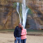
Tuweep: Adventures at the Edge of the Grand Canyon
This place is definitely where, when the world was being built, they ran out of pieces. But I should back up a bit.
The drive here Friday was an adventure, to say the least. We left paved roads just beyond Colorado City/Hildale (we thought about stopping to pick up an extra wife, but I talked my wife Cynthia out of it), and from there found ourselves navigating roads that require a vastly expansive definition of “road” to qualify. Our GPS told us we were pretty much on our own (“Unknown road” soon gave way to “data connection lost”).
After considerable vehicular bushwhacking, we reached a slightly less primitive road and soon encountered a Park Service ranger. She was thoroughly pleasant, confirmed we were on the road to the Tuweep campground, asked to see our back country permit, and sent us on our way.
Continuing on, we passed the ranger station and, a mile or so beyond that, met a group of people on foot heading back to the ranger station. Their story was not good news. Their vehicle, which they said was a good bit bigger than our Sprinter, had dropped its drive shaft and was (a) immobilized and (b) completely blocking passage to/from the campground. We invited them to ride with us back to the ranger station. After they told their story to the rangers, one of them (a ranger, that is) set out to see if the road could be cleared enough for vehicle comings and goings — there is exactly one way into and out of the campground, so if nothing could be done people on either side of the blockage would be stuck. Using a tractor and the stranded motorists’ muscle, enough space was cleared for traffic to resume.
Five miles or so before reaching the campground there is a parking area sporting a warning sign: “Low clearance vehicles should park here.” Turns out the advice was sound. Proceeding much farther made 4 wheel drive, if not essential, a very useful and welcome element of our vehicle. Cynthia did yeoman’s work navigating through it all, but the stress toll was evident. When we reached the campground (an excellent campground, incidentally) Cynthia’s forearms were cramping from having strangled the steering wheel as we bounced along avoiding rocks and similar hazards.
Once we made camp (“making camp” in the Sprinter really means parking it and setting out chairs in which to lounge) we took stock of where we were. A few others were camping as well, but the campground is arranged in a way that gives everyone plenty of space. For people with tents, there are suitable places to pitch them, but the ground is predominantly sandstone. Cacti are everywhere and the sandstone’s earth tones are pleasantly punctuated by small sprays of yellow and purple flowers — delicate petals holding out bravely against the area’s harsh elements.
On day 2 we hiked along the Pack Horse Loop trail, which meanders along a mostly sandstone path, marked by cairns effectively spaced to keep people from getting lost. Ultimately the trail reaches and parallels the Grand Canyon rim, presenting a breathtaking, rather heart pounding, view unlike any I’ve seen anywhere else. This is back country wilderness, so there are no fences or other means of preventing an unwary traveler from taking “a step too far.” The 3000-foot drop from that ledge to the Canyon floor is as sheer as sheer can be. A falling object, such as a person, could count on free-falling for the entire 3000-foot descent. I have pictures to share and hope they capture something of the awesomely, even fearfully, beautiful exposure, but that kind of vastness defies anything other than eye witness experience to truly be grasped.
Tuckup trail departs from the campground’s edge and on day 3 we set out to see what new discoveries it would reveal. As with the Pack Horse Loop trail, Tuckup follows acre upon acre of sandstone, also nicely marked with cairns. It appears that Tuckup was once accessible by motor vehicle, and so where the sandstone gave way to sand and grasses the lingering, if faint, evidence of road kept us on the path. Tuckup doesn’t go to the Canyon rim, but it navigates around beautifully water and wind sculpted sandstone landscapes of various lengths and depths. There were many places a hiker could descend into unknown, unmarked territory, most probably returning eventually to the Canyon rim, but we opted to remain on the trail above it all.
The day was hot (again) and after 2 miles we decided to head back to camp.
After we’d walked for a way, we remarked to one another that our outbound walk had seemed mostly flat, but now we were encountering periodic hills. Not especially steep, but unexpected. We surmised that local, mischievous faeries had altered the return landscape for us, giggling with lilting faerie pleasure as they did so. Well, it turned out those mischievous scamps had caused us to miss a cairn, and so our return path was a slightly different, slightly longer one. That notwithstanding, we made it back to camp none the worse for wear.
Having once navigated the “road” into camp, we knew that going the other direction would be neither easy nor fast. Wishing to get back to Salt Lake before nightfall, we decided to leave on the afternoon of day 3 and camp for the night at Snow Canyon campground, just outside of St. George. From there, we could get back home by late afternoon without difficulty. I say “without difficulty” as if Cynthia’s re-navigating the return road was a trifle. That it was not, but she managed it with grace and the kind of composure that I doubt registered noticeably at the seismology lab in Pasadena. And now we’re home safe and sound.
