Humna ZaidiUnveiling Agricultural Transformation: Final Year Project on Change Detection in Farmlands Using…Imagine witnessing the dynamic evolution of farmlands over time, capturing the subtle shifts and grand transformations that define modern…Jul 19, 202417
Riski SaputraMapping Land Surface Temperature (LST) using Landsat-8 Imagery in ArcMAPLand Surface Temperature (LST) refers to the temperature of the Earth’s surface as measured from above. It’s a crucial parameter in…Apr 9, 20241
FarizaGreetings from Landsat 8 OLI/TIRS and ASTER ImageriesLab Report — Digital Image ProcessingJan 22, 2024Jan 22, 2024
Muhammad RidhoAnalyzing Land Surface Temperature (LST) with Landsat 8 Data in Google Earth EngineLand Surface Temperature (LST) is a crucial environmental parameter with applications ranging from climate change monitoring to urban…Sep 22, 202311Sep 22, 202311
Trinath MahatoSatellites & Swamps: A Spectacular Wetland Exploration with Landsat 8 on Google Earth EngineWetland detection using Landsat 8 imageries on cloud based platform GEE (Google Earth Engine)Oct 24, 2023Oct 24, 2023
Humna ZaidiUnveiling Agricultural Transformation: Final Year Project on Change Detection in Farmlands Using…Imagine witnessing the dynamic evolution of farmlands over time, capturing the subtle shifts and grand transformations that define modern…Jul 19, 202417
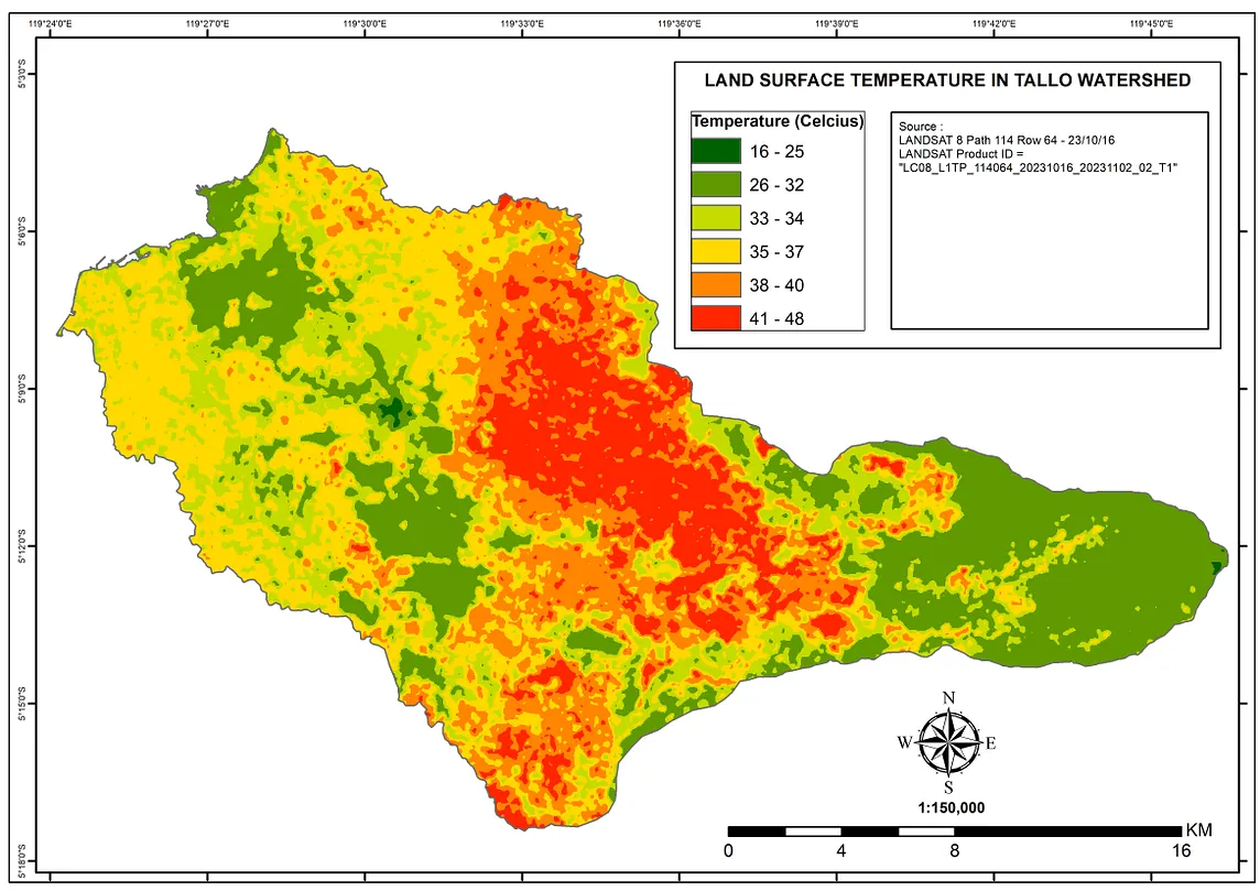
Riski SaputraMapping Land Surface Temperature (LST) using Landsat-8 Imagery in ArcMAPLand Surface Temperature (LST) refers to the temperature of the Earth’s surface as measured from above. It’s a crucial parameter in…Apr 9, 20241
FarizaGreetings from Landsat 8 OLI/TIRS and ASTER ImageriesLab Report — Digital Image ProcessingJan 22, 2024
Muhammad RidhoAnalyzing Land Surface Temperature (LST) with Landsat 8 Data in Google Earth EngineLand Surface Temperature (LST) is a crucial environmental parameter with applications ranging from climate change monitoring to urban…Sep 22, 202311
Trinath MahatoSatellites & Swamps: A Spectacular Wetland Exploration with Landsat 8 on Google Earth EngineWetland detection using Landsat 8 imageries on cloud based platform GEE (Google Earth Engine)Oct 24, 2023
InNerd For TechbyASLANAtmospheric Correction of Satellite images using PythonThis article will help you write the python code to extract the DN's reflectance (Digital Number) of the Satellite images. For this…Feb 12, 20214
GeoSense ✅Calculate the Normalised Burn Ratio (NBR) using Landsat 8 remote sensing data in PythonCalculate the Normalised Burn Ratio (NBR) using Landsat 8.May 10, 20231
Minh NguyenUrban Heat Island Visualization Via Google Earth EnginePart 1: Spatial variationMar 5, 2019