InTowards Data SciencebyAleksei RozanovCan You See the War from Space?Case study of the Russian-Ukrainian warSep 127
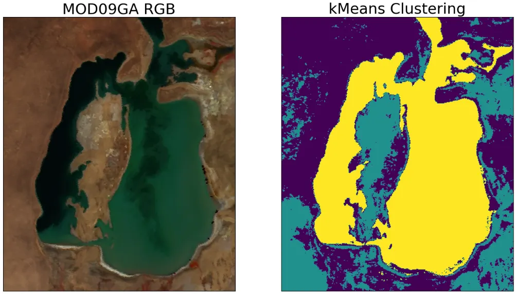
InTowards Data SciencebyAleksei RozanovSemantic Segmentation of Remote Sensing Imagery using k-MeansFrom scratch in python🐍Mar 144
Kiran Katagi“Life in Space: How Astronauts Eat, Live, and Thrive Beyond Earth”Space exploration has always been a fascinating frontier, captivating human imagination for centuries. But have you ever wondered what life…19h ago119h ago1
Planet SnapshotsIssue 139: Salt Pans + Checkerboard Forests + Border Villages + Grand CanyonIn this week’s issue: Calibrating satellites with salt pans, board game forest pattern, a NYT analysis of China’s border strategy…Sep 54Sep 54
DhruvDirect-To-Cell Satellites — How it Works?Imagine a world where cell phone dead zones are a thing of the past. A world where you can seamlessly send texts, make calls, and browse…Jan 4Jan 4
InTowards Data SciencebyAleksei RozanovCan You See the War from Space?Case study of the Russian-Ukrainian warSep 127
InTowards Data SciencebyAleksei RozanovSemantic Segmentation of Remote Sensing Imagery using k-MeansFrom scratch in python🐍Mar 144
Kiran Katagi“Life in Space: How Astronauts Eat, Live, and Thrive Beyond Earth”Space exploration has always been a fascinating frontier, captivating human imagination for centuries. But have you ever wondered what life…19h ago1
Planet SnapshotsIssue 139: Salt Pans + Checkerboard Forests + Border Villages + Grand CanyonIn this week’s issue: Calibrating satellites with salt pans, board game forest pattern, a NYT analysis of China’s border strategy…Sep 54
DhruvDirect-To-Cell Satellites — How it Works?Imagine a world where cell phone dead zones are a thing of the past. A world where you can seamlessly send texts, make calls, and browse…Jan 4
Mário BittencourtHow to generate buffers for remote sensing analysis in coffee farmingIn this article, I’ll teach you how to generate buffers for remote sensing analysis in coffee farming and extract spectral index values…1d ago
InEnrique DansbyEnrique DansSmile, a satellite could be watching youIt didn’t take long: in 2019, when satellites started to be put massively into LEO, or Low Earth Orbit, there was immediate speculation…Feb 202
Mike PucholModeling Starlink capacityPrior attempts to calculate Starlink’s potential for service have been theoretical. We simulate based on the actual constellation.Oct 2, 20226