Felipe Matheus PintoWebGIS: A one-year story of how a friend and I created our own and what I learned during this time.This story began in mid-2023 when I felt the urge to try something new. I’ve been working with GIS since 2018, gaining experience both in…Nov 3
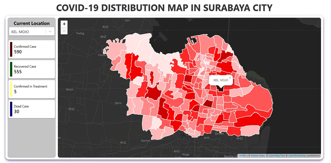
Deddy SetiawanCreate Dynamic Color React-Leaflet with data from GIS GeoJSON file (WebGIS COVID-19)Example of the reslut if you click recovered case in the left sideHello guys, i hope everyone is fine this pandemic. The reason i try to…Jul 25, 2021
Eukarya“Creating Interesting Things That Challenge Conventional Wisdom”: Breaking New Ground in GIS R&D…“Creating Interesting Things That Challenge Conventional Wisdom”: Breaking New Ground in GIS R&D from the NetherlandsNov 1Nov 1
Kishor KrishnaCalculating Circle Bounds in React-Leaflet: A GuideWhen you’re working with React Leaflet, especially with features like circles, you often need to know the geographic bounds that contain…Sep 11Sep 11
EukaryaMaking Open Source Even More User-Friendly: Design Nurtured by Multiculturalism UI/UX Designer Nova…Making Open Source Even More User-Friendly: Design Nurtured by MulticulturalismAug 1Aug 1
Felipe Matheus PintoWebGIS: A one-year story of how a friend and I created our own and what I learned during this time.This story began in mid-2023 when I felt the urge to try something new. I’ve been working with GIS since 2018, gaining experience both in…Nov 3
Deddy SetiawanCreate Dynamic Color React-Leaflet with data from GIS GeoJSON file (WebGIS COVID-19)Example of the reslut if you click recovered case in the left sideHello guys, i hope everyone is fine this pandemic. The reason i try to…Jul 25, 2021
Eukarya“Creating Interesting Things That Challenge Conventional Wisdom”: Breaking New Ground in GIS R&D…“Creating Interesting Things That Challenge Conventional Wisdom”: Breaking New Ground in GIS R&D from the NetherlandsNov 1
Kishor KrishnaCalculating Circle Bounds in React-Leaflet: A GuideWhen you’re working with React Leaflet, especially with features like circles, you often need to know the geographic bounds that contain…Sep 11
EukaryaMaking Open Source Even More User-Friendly: Design Nurtured by Multiculturalism UI/UX Designer Nova…Making Open Source Even More User-Friendly: Design Nurtured by MulticulturalismAug 1
Felipe Matheus PintoUsing ChatGPT to build a simple WebGISChatGPT has become one of the most commented things at the beginning of 2023. You can find a lot of blogs like this one showing tons of…Jan 13, 2023
Felipe Matheus PintoHow to render raster datasets in your WebGISYou are starting to create your own web application, but then you realize, how can I render raster datasets? I’ll provide you with some…Nov 3, 2023
EukaryaThe New Possibilities of 3D City Models Brought by Re:Earth — Results of Eukarya’s Initiatives in…1. Major Updates to PLATEAU VIEW 3.0Nov 29