Farmonaut SupportApplications of Satellite Imagery Bands — Part 2: Vegetataion Red Edge (B5, B6, B7, B8A)The Red Edge band (B5, B6, B7, B8A) is located between the Red band (B4) and the NIR band (B8), without overlap.Jan 9, 2019Jan 9, 2019
Farmonaut SupportImpact Analysis of Volcano-Induced-Tsunami in Indonesia Using FarmonautA tsunami swept across Indonesia’s islands of Sumatra and Java the night of December 22, just before 9:30 p.m. local time. There was no…Dec 27, 2018Dec 27, 2018
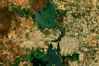
Farmonaut SupportAnalyzing Water Level of Lakes of Udaipur (India) Using FarmonautWith the threats of climate change on the horizon, every year hundreds of lakes get dried up and get extinct due to ever changing and…Dec 20, 2018Dec 20, 2018
Farmonaut SupportApplications of Satellite Imagery Bands — Part 1: Coastal Aerosol (B1), Blue (B2), Green (B3), and…With these series of articles, we wish to provide a comprehensive analysis of what, where and how the satellite imagery accessed through…Dec 13, 2018Dec 13, 2018
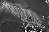
Farmonaut SupportMapping Volcanic Activity Using FarmonautWe mapped Mount Veniaminof’s volcanic activity using the short wave infrared satellite imagery accessed through our system.Dec 6, 2018Dec 6, 2018
Farmonaut SupportTime Lapse of Californian FireThe spread and extent of fire in California is massive and devastating. So, we decide to have a look on the imagery of the last month over…Nov 12, 2018Nov 12, 2018