Joshua Tunde-oyewumiENROUTE KANO-FIR CHART, NIGERIA AIRSPACE MANAGEMENT AGENCYIt was my Internship at the Muritala Muhammad Airport, NAMA. I was in the cartography department, the department was using AutoCAD to…Jul 8, 20231Jul 8, 20231
Joshua Tunde-oyewumiFINAL YEAR PROJECTMy final year project at the University of Technology, Akure was based on gulley erosion vulnerability assessment in a particular study…Jul 8, 2023Jul 8, 2023
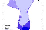
Joshua Tunde-oyewumiWATERSHED DELINEATIONwatershed map was requested and was created in the ArcGIS environment after the production of aspect, slope, and contour maps.Jul 8, 2023Jul 8, 2023
Joshua Tunde-oyewumiVEGETATIONAL INDICES AND LAND USE CHANGESThe client requested different vegetational indices maps and the land use/cover map changes over 20 years, which include, Normalized…Jul 8, 2023Jul 8, 2023
Joshua Tunde-oyewumiIWO DAM, OSUN STATE, NIGERIAThe client requested a map showing the road connection networksleading to the iwo dam, to which she specifically said, “I want a map that…Jul 8, 2023Jul 8, 2023